

Journal of Climate Change and Pollution
ISSN:
3108-2025 (Online)
DOI Prefix (Crossref): 10.67238
 Download PDF

Tigray Environmental Protection and Climate Change Authority, Mekelle, Ethiopia
ABSTRACT
Background
Armed conflict severely exacerbates climate vulnerability and ecosystem degradation, yet conflict-sensitive environmental mainstreaming remains critically neglected in river basin planning. Focusing on the Tigray portion of the Tekeze River Basin in northern Ethiopia following the 2020–2022 armed conflict, this study provides a practical scientific basis to integrate environmental and climate priorities into the ongoing 15-year Tekeze Basin Plan.
Methods
We applied a Driver-Pressure-State-Impact-Response (DPSIR) framework integrating multi-temporal remote sensing (Sentinel-2A and Landsat 8/9; 2018–2024), LULC/NDVI mapping, field surveys across six urban–rural corridors, and key informant interviews (n=48).
Results
Primary conflict-driven Pressures induced 403 km² of vegetation loss, unmonitored mercury/cyanide contamination from artisanal mining, and widespread waste management failure across the Tigray sub-basin. Basin land cover is currently dominated by sparse vegetation (76.93%) and cropland (39.60%), with forest cover limited to 13.39% and surface water to 0.40%. Existing Responses are hampered by institutional collapse, absent monitoring networks, and weak enforcement, escalating water scarcity, food insecurity, and toxic ecological risks.
Conclusion
We deliver a prioritized environmental agenda, a phased implementation roadmap, and a novel Integrated Conflict-Sensitive Environmental and Social Safeguarding framework. This work offers a scalable template for climate resilience and ecosystem restoration in conflict-affected dryland basins globally. Beyond documenting environmental degradation, this study develops and operationalizes the Integrated Conflict-Sensitive Environmental and Social Safeguarding (ICSESS) framework, which transforms DPSIR assessment into a decision-support system for river basin planning. The framework provides a transferable model for integrating environmental restoration, climate resilience, and institutional recovery into Integrated River Basin Management (IRBM) in conflict-affected regions worldwide.
Keywords: Environmental Mainstreaming; DPSIR And ICSESS Frameworks; River Basin Planning; Climate Resilience; Post-Conflict Recovery; Ecosystem Restoration; Tekeze River Basin; Tigray; Ethiopia
INTRODUCTION
Environmental Mainstreaming in Post-Conflict River Basin Planning
Integrated River Basin Management (IRBM) is widely recognized as the principal framework for coordinating land, water, and ecosystem management within hydrological boundaries to achieve environmental sustainability, economic development, and social equity [1]. However, conventional IRBM assumes institutional stability, effective governance, functioning environmental monitoring systems, and predictable resource availability [2]. These assumptions rarely hold in conflict-affected regions, where environmental institutions collapse, critical infrastructure is destroyed, regulatory enforcement weakens, and ecosystem degradation accelerates [3-5]. Consequently, environmental recovery becomes inseparable from basin governance. Environmental mainstreaming, the systematic integration of environmental considerations into development planning, sectoral policies, and reconstruction investments, is therefore a prerequisite for sustainable post-conflict recovery rather than a supplementary planning exercise [6]. Without explicit environmental safeguards, reconstruction may inadvertently intensify ecosystem degradation through uncontrolled urban expansion, poorly regulated industrial recovery, unsustainable extraction of natural resources, and ineffective waste management [7-8]. River basin planning in conflict-affected regions must therefore evolve beyond conventional water-resource management to integrate environmental restoration, climate resilience, and institutional rebuilding.
Conflict, Climate Change, and Environmental Degradation
Armed conflict and climate change interact as mutually reinforcing drivers of environmental degradation. Conflict directly damages landscapes through military operations, destruction of environmental infrastructure, population displacement, and disruption of ecosystem processes, while indirectly weakening governance, environmental monitoring, regulatory compliance, and natural resource management [3,9]. These institutional failures frequently stimulate environmentally destructive livelihood strategies, particularly the rapid expansion of informal artisanal and small-scale mining (ASM). Globally, ASM supports the livelihoods of approximately 130–270 million people [10,11], yet conflict settings commonly promote illegal extraction, weak environmental oversight, and hazardous mining practices [12,13]. Mercury and cyanide used during mineral processing contaminate soils and water bodies, impair aquatic ecosystems, and generate persistent human health risks [14-16]. Similar environmental threats arise from damaged industrial facilities, where uncontrolled release of untreated effluents and hazardous chemicals may further degrade river basin ecosystems.
Climate change amplifies these pressures by increasing droughts, floods, and land degradation while reducing ecosystem resilience [9]. Within the Tekeze River Basin, agriculture and forestry contribute approximately 52% and 37% of greenhouse gas emissions, respectively, and basin-wide emissions are projected to increase nearly fourfold by 2045 under a business-as-usual scenario [9]. These interacting pressures underscore the need for integrated basin planning that simultaneously addresses environmental restoration, climate adaptation, mitigation, and institutional resilience.
Environmental Transformation in the Tekeze River Basin
The Tigray portion of the Tekeze River Basin exemplifies the environmental consequences of conflict in dryland river systems. Northern Ethiopia has a long history of mineral extraction, with artisanal mining contributing substantially to rural livelihoods following mining sector liberalization in 1991 [17-18]. Prior to the 2020–2022-armed conflict, mining activities operated within an evolving regulatory framework intended to improve environmental compliance [19-21]. The conflict fundamentally altered this governance landscape by weakening institutions responsible for environmental licensing, monitoring, and enforcement, thereby facilitating rapid expansion of informal mining and increasing the use of hazardous extraction methods [9,19,22]. Beyond mining, widespread destruction of municipal services, healthcare waste infrastructure, wastewater treatment facilities, and industrial operations has intensified environmental pollution. Chemical releases from damaged industrial facilities, including the Sheba Tannery and Almeda Textile Factory, together with untreated municipal and healthcare wastes, represent emerging threats to surface water quality, ecosystem integrity, and public health [16]. These cumulative pressures demonstrate that post-conflict environmental degradation extends well beyond water-resource management and requires integrated, basin-scale interventions.
DPSIR Framework and Knowledge Gap
The Driver–Pressure–State–Impact–Response (DPSIR) framework provides a systems-based approach for understanding the causal relationships linking socio-economic drivers, environmental pressures, ecosystem condition, ecological and human impacts, and management responses [23]. Because it explicitly captures interactions among environmental, institutional, and socio-economic processes, DPSIR is particularly suited to conflict-affected environments characterized by multiple interacting stressors and complex recovery pathways [24]. Despite its widespread application in environmental assessment, DPSIR has rarely been translated into an operational framework capable of guiding post-conflict river basin planning. Existing Integrated River Basin Management approaches largely assume stable governance and therefore provide limited guidance for mainstreaming environmental recovery, climate resilience, institutional reconstruction, and social safeguards into long-term basin governance. This limitation represents a critical knowledge gap for conflict-affected dryland basins facing simultaneous environmental degradation and climate risks.
Study Objectives
This study addresses this gap by developing an operational framework for integrating environmental sustainability and climate resilience into long-term river basin planning using the conflict-affected Tigray portion of the Tekeze River Basin as a representative case study. Specifically, the study:
- Assesses environmental conditions using the DPSIR framework.
- Identifies priority environmental and climate issues for integration into the ongoing 15-year Tekeze River Basin Plan.
- Develops a phased implementation roadmap for environmental and climate mainstreaming.
- Proposes an Integrated Conflict-Sensitive Environmental and Social Safeguarding (ICSESS) framework that operationalizes environmental restoration, climate adaptation and mitigation, gender equality, resilient livelihoods, and institutional strengthening within long-term basin governance.
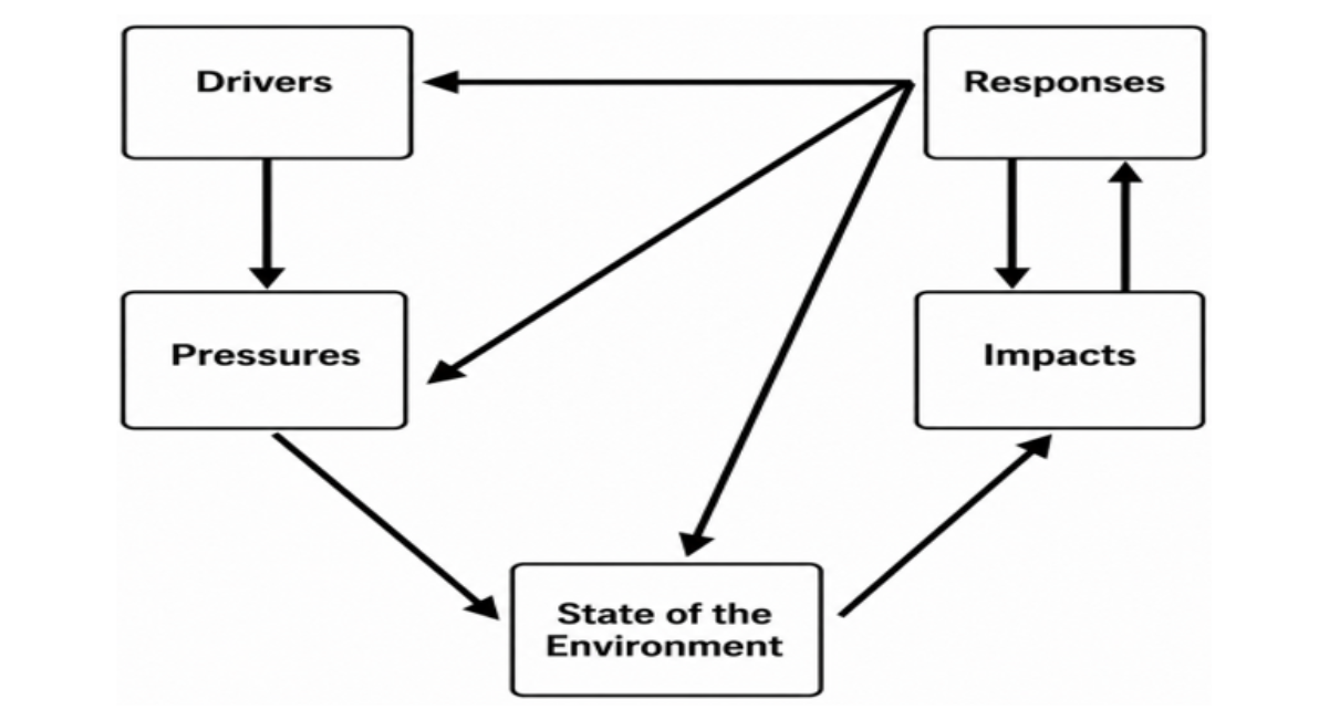
Figure 1: Conceptual Decision Framework Linking DPSIR Assessment to Basin Planning
MATERIALS AND METHODS
Study Area
The study was conducted in the Tigray portion of the Tekeze River Basin, northern Ethiopia (12°15′–14°57′ N; 36°27′–39°59′ E), one of Ethiopia's largest river basins (>86,000 km²) [25-26]. The basin is the principal hydrological system of Tigray, supporting domestic water supply, irrigated and rain-fed agriculture, biodiversity conservation, and multiple ecosystem services essential for regional livelihoods and economic development [27].
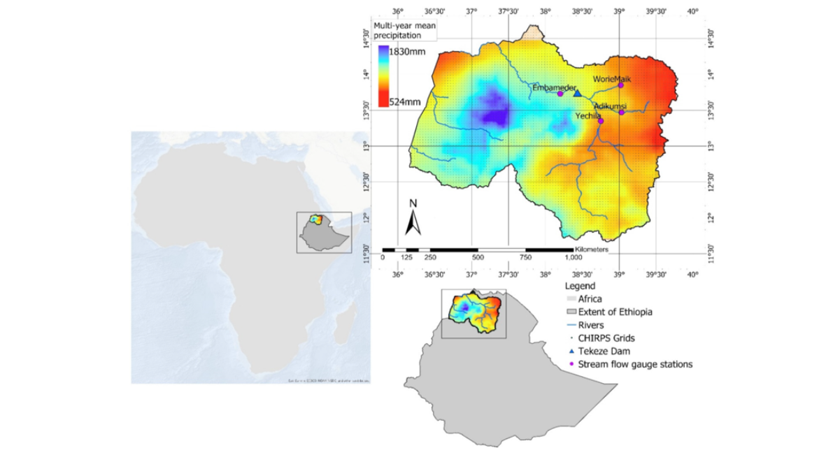
Figure 2: Location and Extent of The Tekeze River Basin Showing the Basin Boundary, Major River Network, And Regional Setting Within Ethiopia.
The assessment focused on the upper and middle Tekeze sub-basins, encompassing major headwater catchments and the region's principal urban, agricultural, and ecological landscapes. Elevation ranges from approximately 500 m in the western lowlands to nearly 4,000 m a.s.l. in the eastern highlands, while annual rainfall varies between 400 and 1,160 mm, reflecting pronounced climatic and ecological gradients [28]. Field investigations were undertaken in six major urban centres (Mekelle, Shire, Axum, Adwa, Wukro, and Abi-Adi), representing the basin's primary population, industrial, and service hubs [9]. Besides to Tigray and Amhara Regions of Ethiopia, the basin forms part of a trans-boundary landscape bordering Eritrea and Sudan. Its strategic importance for Tigray regional water security, ecosystem resilience, and post-conflict reconstruction makes it an appropriate case study for developing environmental mainstreaming approaches for conflict-affected river basins.
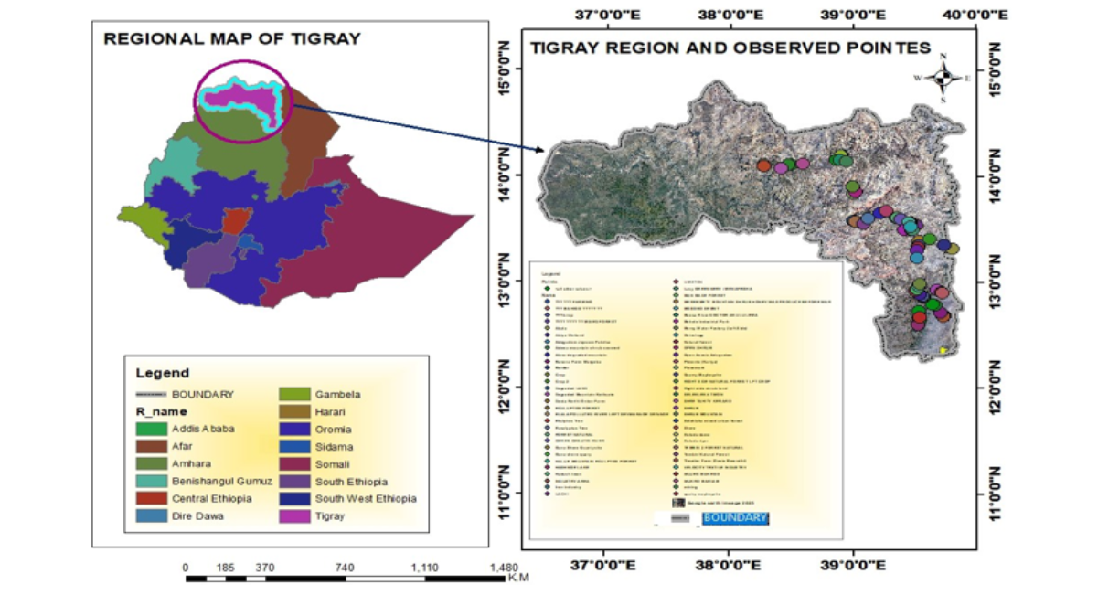
Figure 3: Spatial framework of the study area. (A) Administrative location of the Tigray Region within Ethiopia. (B) Distribution of ground-truth points used for land-use/land-cover classification, model training, validation, and spatial change detection
Integrated Methodological Framework
A multi-scale assessment framework was developed to evaluate post-conflict environmental conditions and identify priorities for sustainable river basin management. The framework integrated geospatial analysis, field-based environmental investigations, industrial and healthcare facility assessments, and institutional evaluations, generating complementary evidence across environmental, socio-economic, and governance dimensions.
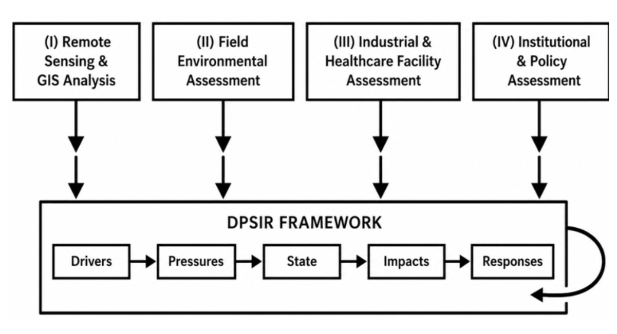
Figure 4: Integrated methodological framework illustrating the four-stage assessment process, including (i) remote sensing and GIS analysis, (ii) field environmental assessment, (iii) industrial and healthcare facility assessment, (iv) institutional and policy assessment, and integration through the DPSIR framework.
Remote Sensing and Geospatial Analysis
Satellite Data Acquisition: Multi-temporal satellite imagery was analyzed to quantify land-use/land-cover (LULC) change, vegetation dynamics, and ecosystem degradation from a pre-conflict baseline to the post-conflict period. The analysis utilized three satellite datasets:
- Landsat 8/9 OLI/TIRS: Provided regional-scale multispectral observations at 30 m spatial resolution (15 m panchromatic) with a 16-day temporal resolution. Landsat- 8 imagery (path 169/170, row 50/51) acquired during the dry season (January–March 2018) was used for the pre-conflict baseline. Landsat 8 and 9 imagery (path 169/170, row 50/51) acquired during the dry season (January–March 2024) was used for the post-conflict assessment. The dry-season acquisition minimized cloud cover and seasonal vegetation variability, ensuring comparability between time periods.
- Sentinel-2A MSI: Provided finer-resolution spatial characterization at 10–20 m resolution with a 5-day temporal resolution for detailed LULC and vegetation mapping. Sentinel-2A tiles (T37PDQ, T37PDK, T37PEQ, T37PEK) acquired during the dry seasons of 2018 and 2024 (January–March) were used to complement Landsat observations.
- MODIS MOD13Q1: Provided a consistent 250 m, 16-day vegetation-index record for NDVI time-series analysis. The full time series from January 2018 to December 2024 was acquired, providing 168 temporal observations for trend and breakpoint analysis [29-31].
|
Dataset |
Period |
Spatial Resolution |
Temporal Resolution |
Acquisition Dates |
Principal Application |
|
Landsat 8/9 OLI/TIRS |
2018, 2024 |
30m multispectral; 15 m pan |
16 days |
Jan–Mar 2018; Jan–Mar 2024 |
LULC and change detection |
|
Sentinel-2A MSI |
2018, 2024 |
10–20 m |
5 days |
Jan–Mar 2018; Jan–Mar 2024 |
Detailed LULC/vegetation mapping |
|
MODIS MOD13Q1 |
2018–2024 |
250 m |
16 days |
Jan 2018–Dec 2024 |
NDVI time-series analysis |
Table 1: Satellite Datasets and Analytical Specifications
Image Preprocessing: Satellite imagery was preprocessed for atmospheric, geometric, cloud, and spatial consistency. Landsat surface reflectance was prepared using the LaSRC (Landsat 8 Surface Reflectance Code) atmospheric-correction procedure, while Sentinel-2 imagery was processed using Sen2Cor (version 2.8) to obtain bottom-of-atmosphere reflectance [32-33]. All imagery was co-registered to UTM Zone 37N, WGS84 datum (EPSG: 32637) using ground control points with RMSE < 0.5 pixels. Cloud and cloud-shadow contamination were masked using the Fmask (Function of mask) algorithm, version 4.0. Only scenes with ≤10% cloud cover were prioritized for analysis. Where multiple scenes were required to achieve complete spatial coverage, median compositing was used to reduce residual cloud contamination and seasonal differences [34-36]. Topographic correction was applied using the C-correction method with a 30 m SRTM digital elevation model to minimize illumination variations across the complex terrain.
LULC Classification: A supervised Random Forest (RF) classifier was used to generate LULC maps for 2018 and 2024. RF was selected because of its robustness for multispectral classification, ability to accommodate multiple predictor variables, and resistance to over fitting [37]. Eight classes were mapped: cropland, forest, shrub land/open shrub land, grassland, bare soil, built-up land, water bodies, and wetlands.
Predictor variables included: (i) spectral bands (all 11 Landsat bands and all 13 Sentinel-2 bands); (ii) vegetation indices (NDVI, NDWI, SAVI, and Enhanced Vegetation Index [EVI]); (iii) texture measures (gray-level co-occurrence matrix [GLCM] texture features: contrast, dissimilarity, homogeneity, angular second moment, energy, and correlation calculated from the NIR band); (iv) terrain variables (elevation, slope, and aspect derived from the 30 m SRTM DEM); and (v) ancillary spatial information (proximity to roads and water bodies, calculated as Euclidean distance). These variables were selected to improve discrimination among spectrally similar classes in the heterogeneous Tigray landscape [38-39]. The RF model was initially parameterized with 500 trees and optimized through grid search and 10-fold cross-validation. The optimal parameters were: ntree = 500, mtry = √p (where p is the number of predictor variables), node size = 5, and maximum depth = 50. The optimized model was subsequently applied to the study area for both comparison years.
Training and Validation Data: A total of 384 georeferenced field ground-truth points were collected during the 2024–2026 field Programme (November 2024 to March 2026). Points represented all eight LULC classes and were recorded using handheld GPS receivers (Garmin GPSMAP 64sx) with approximately 3–5 m positional accuracy, geo-tagged photographs, and standardized land-cover descriptions using a modified FAO land-cover classification protocol. The 384 observations constituted the direct field ground-truth component. They were supplemented by stratified visual interpretation of high-resolution Google Earth imagery (2018 and 2024), historical land-use information from previous studies, and ancillary spatial datasets to construct the complete reference dataset. The resulting dataset contained 5,560 training samples and 1,835 independent validation samples, with sample sizes per class proportional to class area to ensure adequate representation.
|
LULC Class |
Training |
Validation |
|
Cropland |
1,200 |
400 |
|
Forest |
950 |
320 |
|
Shrub land |
850 |
280 |
|
Grassland |
720 |
240 |
|
Bare soil |
680 |
220 |
|
Built-up |
590 |
190 |
|
Water bodies |
310 |
100 |
|
Wetlands |
260 |
85 |
|
Total |
5,560 |
1,835 |
Table 2: Distribution of LULC Training and Independent Validation Samples
Classification Accuracy Assessment: Classification accuracy was evaluated using the independent validation dataset. Overall accuracy, producer's accuracy, user's accuracy, Kappa coefficient, and class-specific F1 scores were calculated [40]. The F1 score, representing the harmonic mean of precision (user's accuracy) and recall (producer's accuracy), was calculated as F1 = 2 × (Precision × Recall)/(Precision + Recall). The final classification achieved 85.6% overall accuracy and a Kappa coefficient of 0.83 (95% CI: 0.81–0.85), with class-specific F1 scores ranging from 0.80 for grassland to 0.92 for water bodies.
|
LULC Class |
Producer's Accuracy |
User's Accuracy |
F1 Score |
|
Cropland |
1 |
0.85 |
0.86 |
|
Forest |
0.91 |
0.89 |
0.9 |
|
Shrub land |
0.84 |
0.82 |
0.83 |
|
Grassland |
0.79 |
0.81 |
0.8 |
|
Bare soil |
0.85 |
0.83 |
0.84 |
|
Built-up |
0.82 |
0.86 |
0.84 |
|
Water bodies |
0.94 |
0.91 |
0.92 |
|
Wetlands |
0.86 |
0.83 |
0.84 |
|
Overall |
1 |
1 |
0.85 |
Table 3: LULC Classification Accuracy
LULC Change Detection: Post-classification comparison was used to quantify transitions between 2018 and 2024. Transition matrices identified conversions among classes, while net and relative changes were calculated as:
Net change = A₂₀₂₄ − A₂₀₁₈
Relative change (%) = [(A₂₀₂₄ − A₂₀₁₈)/A₂₀₁₈] × 100
Where A denotes the area of the respective LULC class, Net change, gross change, and persistence were distinguished to avoid conflating total transitions with net class-area change [41,42]. A minimum mapping unit of 0.09 ha (3 × 3 pixels for Landsat) was applied to reduce classification noise.
Vegetation Assessment (NDVI and BFAST): Vegetation condition was assessed using the Normalized Difference Vegetation Index (NDVI):
Where NIR and Red represent near-infrared (Band 8 for Sentinel 2 Band 5 for Landsat) and red (Band 4 for Sentinel-2, Band 4 for Landsat) reflectance, respectively [43]. MODIS MOD13Q1 provided the principal temporal dataset, while Sentinel-2 NDVI provided higher-resolution spatial characterization [44,45]. A 16-day MODIS NDVI time series was generated for January 2018–December 2024. Seasonal patterns were evaluated for dry (October–March) and wet (April–September) periods and annual mean NDVI was calculated. For spatial interpretation, NDVI was grouped into five vegetation-condition classes based on the standard classification scheme: non-vegetated/water (NDVI < 0.201), sparse vegetation/bare soil (NDVI 0.202–0.252), moderate vegetation/cropland (NDVI 0.253–0.322), dense vegetation (NDVI 0.323–0.434), and healthy vegetation (NDVI > 0.435).
The Breaks for Additive Season and Trend (BFAST) approach was applied to the MODIS NDVI series to identify structural changes in trend and seasonal components [46-48]. The series was decomposed into trend, seasonal, and remainder components using an additive decomposition model: Y_t = T_t + S_t + e_t where Y_t is the observed NDVI at time t, T_t is the trend component, S_t is the seasonal component, and e_t is the remainder. Breakpoint detection was applied to the trend component using the BFAST monitor algorithm, with statistical significance assessed at p<0.05. Model selection used the Akaike Information Criterion (AIC), with a maximum of five candidate breakpoints per pixel. Detected breakpoints were interpreted jointly with LULC transitions, field observations, climatic information (rainfall and temperature data from the Ethiopian Meteorological Institute), and documented conflict-related disturbances.
Field Environmental Assessment
Site Selection and Sampling Strategy: A purposive, multi-domain sampling strategy was used because the objective was to identify environmental pressure sources, sensitive receptors, infrastructure failures, and recovery priorities rather than estimate population prevalence. Eight urban centres were purposively selected to capture geographic, demographic, environmental, and functional variation across the basin [22,32,34,49,50]. Selection criteria included: (i) representation of major population centres (population > 50,000), (ii) presence of industrial and healthcare facilities, (iii) documented environmental degradation, (iv) accessibility under post-conflict security constraints, and (v) institutional presence for key informant interviews. Within each urban center, a stratified purposive sampling approach was used to select observation locations. Stratification was based on land-use type (industrial, residential, commercial, agricultural, and riparian), distance from the urban center (core, peri-urban, and rural), and proximity to water bodies. This stratification ensured comprehensive coverage of the diverse environmental gradients present in each study site.
Field Observation Dates and Frequency: Field investigations were conducted over multiple campaigns: Campaign 1 (Pilot): December 2023 (Mekelle only) – protocol testing and standardization; Campaign 2: November 2024–January 2025 – primary field data collection (dry season); Campaign 3: March–April 2025 – extended observations (dry season); Campaign 4: August–September 2025 – wet season validation and supplementary observations; and Campaign 5: January–March 2026 – final validation and quality control. Each observation point was visited at least twice (dry and wet season) where security conditions permitted. A total of 324 georeferenced environmental observation points were recorded across the eight urban centres, major river systems including the Geba, and tributaries, wetlands in Tsaeda Emba Woreda, industrial locations, healthcare facilities, and peri-urban/rural environments [21,24,51].
|
Observation Category |
N |
Sampling Rationale |
|
Solid-waste dumpsites/landfills |
8 |
Identify waste management failures and contamination sources |
|
Wastewater discharge points |
14 |
Characterize point-source pollution |
|
Industrial facility locations |
14 |
Assess industrial environmental performance |
|
Healthcare facility locations |
9 |
Evaluate healthcare waste management |
|
River |
21 |
Characterize water quality and hydrological condition |
|
Wetland |
62 |
Assess sensitive ecosystem status |
|
Agricultural-land observation points |
84 |
Evaluate agricultural practices and soil condition |
|
Forest/vegetation observation points |
56 |
Characterize vegetation condition |
|
Urban environmental infrastructure |
56 |
Assess urban environmental services |
|
Total |
324 |
Field Procedures and Quality Control: The field protocol was pilot-tested in Mekelle in December 2023 and subsequently standardized. Data were collected using structured checklists, Kobo Toolbox forms, field notebooks, GPS receivers (Garmin GPSMAP 64sx, 3–5 m accuracy), and photographic documentation. Each observation point was documented with: (i) GPS coordinates (UTM Zone 37N, WGS84), (ii) geo-tagged photographs (minimum 4 per point, cardinal directions), (iii) field notes on observed environmental conditions, (iv) standardized checklists completed for each observation category, and (v) laboratory samples where applicable. Observers (n=12) received two weeks of training in standardized assessment procedures. Paired observations were conducted at 10% of selected locations (n=61) to evaluate inter-observer consistency, achieving >90% agreement on categorical variables and high correlation (R² > 0.90) on continuous measurements. Data were subsequently incorporated into a geospatial database (Postgre SQL/Post GIS) and coded according to DPSIR domains [20,52].
Industrial and Healthcare Facility Assessment
Industrial Assessment: Nineteen industrial facilities were purposively selected based on sectoral representation, operational scale, pollution potential, geographic distribution, availability of pre-conflict records, and accessibility. The sample included food and beverage, leather, construction/cement/stone, garment/textile, and soap-manufacturing facilities. Selection criteria included: (i) documented pre-conflict environmental compliance status, (ii) evidence of conflict-related damage, (iii) post-conflict operational status, and (iv) accessibility under security constraints.
Facility assessments examined wastewater generation and discharge, treatment infrastructure, pollution-control systems, hazardous-material handling, monitoring, spill risks, safeguards, and regulatory compliance [53-54]. Wastewater measurements included pH, temperature, electrical conductivity, dissolved oxygen, TSS, COD, BOD₅, sulfides, nutrients (nitrates, phosphates), and selected heavy metals (Cr, Pb, Cd, Hg, Zn, Cu) using portable field meters (Hanna Instruments, YSI) and laboratory analysis. Quality assurance included instrument calibration (daily), duplicate measurements (10% of samples), standard checks (5% of samples), and laboratory validation (15 samples compared between field and laboratory measurements). Analytical procedures followed Standard Methods for the Examination of Water and Wastewater [55]. Results were compared against Ethiopian Environmental Protection Authority industrial effluent standards and WHO guidelines.
Healthcare Assessment: Nine hospitals were purposively selected according to geographic representation, facility size, service coverage, patient load, availability of pre-conflict records, and post-conflict accessibility. Selection criteria included: (i) referral or district hospital status, (ii) patient capacity > 50 beds, (iii) documented healthcare-waste management practices pre-conflict, and (iv) accessibility under post-conflict security constraints.
Assessments examined source segregation, collection, temporary storage, treatment infrastructure, incinerator functionality, open burning or burial, healthcare wastewater, infrastructure damage, staffing, training, and environmental compliance. Structured observations, infrastructure assessments, record reviews (waste generation records from 2018 and 2024 where available), and interviews with healthcare and waste-management personnel (n=3–5 per hospital) were undertaken. Assessment criteria were informed by Ethiopian healthcare-waste requirements (Food, Medicine and Health Care Administration and Control Authority Directive No. 15/2011) and WHO guidance for safe healthcare-waste management [56-57]. Healthcare waste was categorized as: (i) infectious waste, (ii) pathological waste, (iii) pharmaceutical waste, (iv) sharps, (v) chemical waste, and (vi) general waste. Incinerator functionality was assessed using a standardized scoring system examining temperature capability, emissions control, operational status, and maintenance records. Post-conflict health-system disruption was considered when interpreting facility-level findings [46,48].
Water Resources, Wetlands, and Ecosystem Assessment
Water-resource assessment included rivers, streams, wastewater discharge points, wetlands, drainage systems, and sensitive ecosystems. River and stream monitoring covered the Geba, Tsirare, Angereb, Zarema, and major tributaries because of their basin hydrological and ecological importance [21,24,43]. Monitoring points were selected at about 15 km intervals along major rivers, at all major confluences, and upstream/downstream of industrial and urban discharge points.
Field parameters included pH, EC, dissolved oxygen, TSS, temperature, and visual indicators of pollution (color, odour, turbidity, foam), sedimentation, erosion, flow alteration, solid-waste accumulation, vegetation condition, and infrastructure damage. Water-quality measurements followed standardized analytical procedures [44], using calibrated field meters (Hanna Instruments HI9829 multi parameter probe) and laboratory-validated samples. The wetland inventory in Tsaeda Emba Woreda comprised 16 sites covering approximately 335 ha. Sites were identified from satellite imagery and field-verified, mapped using GPS and satellite imagery, and assessed for vegetation condition (cover, diversity, presence of invasive species), hydrological characteristics (water depth, flooding extent, flow connectivity), land-use pressure, and threats (drainage, grazing, conversion). Wetlands were included because of their hydrological, ecological, and carbon-related functions and their sensitivity to land-use and climate pressures [28,39].
Key-Informant Interviews
Participant Selection Criteria: A total of 48 key informants were purposively selected using criterion-based and maximum-variation sampling. The selection criteria were designed to ensure comprehensive institutional and sectoral coverage:
Primary criteria (required): (i) Institutional responsibility for environmental management, natural resource governance, or public health; (ii) Minimum 2 years of professional experience in their respective sector; (iii) Direct involvement in environmental management or recovery activities during or after the conflict; and (iv) Representation of relevant agencies or technical institutions. : (v) Administrative-level diversity (federal, regional, zonal, woreda); (vi) Sectoral diversity (environment, water, health, industry, mining, agriculture, planning); (vii) Geographic diversity (representation from all eight urban centres); and (viii) Gender diversity (target 30% female representation).
Participants represented regional government agencies (n=16), municipalities (n=8), environmental authorities (n=8), industries (n=8), and technical institutions/academia (n=8). The sampling frame was developed through institutional stakeholder mapping and snowball sampling within each sector. The purpose of KIIs was to identify institutional mechanisms, environmental-management constraints, conflict-related disruptions, governance gaps, and recovery priorities rather than estimate population-level attitudes.
Interview Procedures: Semi-structured interviews were conducted between November 2024 and March 2026 (parallel with field campaigns). Interviews lasted approximately 60–120 min, with a mean duration of approximately 75 min. Interviews were conducted in Tigrinya or Amharic at the Federal according to participant preference by three trained interviewers with experience in qualitative research and local language proficiency. Audio recording was undertaken only with permission (n=42, 87.5%); otherwise, detailed notes were taken (n=6, 12.5%). Recordings were transcribed verbatim in the original language and translated into English for analysis. Translation was verified by a second translator for 20% of transcripts to ensure accuracy.
The interview guide covered: (i) environmental change observed before, during, and after conflict; (ii) conflict-related damage to environmental infrastructure; (iii) environmental pressures and pollution sources; (iv) institutional disruption and capacity constraints; (v) pollution management practices (municipal, industrial, healthcare); (vi) water resources and ecosystem conservation; (vii) regulatory enforcement and governance mechanisms; (viii) recovery priorities and implementation constraints; and (ix) recommendations for integrated basin management.
Qualitative Data Coding and Thematic Analysis: Interview transcripts, field notes, and relevant institutional documents were analyzed using thematic analysis following the six-phase framework of Braun and Clarke [58]: (1) data familiarization, (2) initial code generation, (3) theme identification, (4) theme review, (5) theme definition, and (6) report production.
A hybrid deductive–inductive coding strategy was used: Deductive codes were derived from DPSIR (Drivers, Pressures, State, Impacts, Responses) and ICSESS (Environmental Safeguarding, Climate Integration, Gender, Livelihoods, Institutional Strengthening) domains, creating an initial codebook of 35 predefined codes. Inductive codes captured recurring empirical themes not covered by the deductive framework, allowing new themes to emerge from the data. This iterative process added 22 additional codes, resulting in a final codebook of 57 codes.
Two researchers independently coded the first 10 interviews (21%) using the shared codebook to assess inter-coder reliability. Initial inter-coder agreement was 78%; discrepancies were resolved through consensus, and the codebook was refined. The remaining interviews were coded independently, with regular consensus meetings to maintain consistency. Final inter-coder agreement was 92%. Code frequencies, co-occurrences, and higher-order themes were examined using NVivo 14 software. Themes were organized hierarchically, and thematic networks were developed to illustrate relationships between codes and themes. Qualitative findings were used to contextualize environmental measurements and identify institutional mechanisms rather than substitute for direct environmental evidence.
Institutional and Legal-Policy Assessment
Environmental governance was evaluated through a review of policy and regulatory instruments together with semi-structured interviews involving 48 key informants from regional government agencies, municipalities, ecological experts at woreda governmental service Offices (TEPCCA woreda representatives), industries, and technical institutions [9,59]. A structured review of 15 environmental policy, legal, regulatory, and institutional instruments was conducted. Instruments were selected based on relevance to environmental assessment, pollution control, industrial effluent, hazardous waste, healthcare waste, wastewater management, natural-resource protection, permitting, monitoring, enforcement, institutional mandates, and inter-agency coordination.
Documents were reviewed through a systematic process: document acquisition → screening for relevance → thematic extraction → DPSIR/ICSESS coding → regulatory-gap analysis → evidence-matrix integration. Instruments reviewed included the Ethiopian Environmental Policy (1997), Environmental and Social Impact Assessment Proclamation (No. 1371/2025), Pollution Control Proclamation (No. 300/2002), Industrial Effluent Management Guidelines, Healthcare Waste Management Directive, Solid Waste Management Proclamation (No. 1383/2025), Mining Operations Proclamation (No. 678/2010), and institutional mandates from relevant government agencies. Formal mandates and requirements were compared with field observations, stakeholder evidence, and available implementation records. Particular attention was given to institutional capacity, financing, monitoring, enforcement, coordination, and post-conflict continuity [1,4,5,20,60].
Data Analysis
Environmental data were synthesized using the Driver–Pressure–State–Impact–Response (DPSIR) framework to establish causal linkages between conflict-related drivers, environmental pressures, ecosystem condition, ecological and socio-economic impacts, and management responses [25]. The framework provided the analytical basis for identifying priority intervention areas for environmental mainstreaming within basin planning.
DPSIR Evidence Integration
Spatial, environmental, qualitative, and institutional evidence were integrated using DPSIR [20,39]. Evidence was first coded into Drivers, Pressures, State, Impacts, and Responses using predefined operational definitions derived from the EEA DPSIR typology:
- Drivers: Underlying socio-economic and institutional forces that generate pressures
- Pressures: Direct human activities that affect the environment
- State: Physical, chemical, and biological condition of the environment
- Impacts: Effects on ecosystem functioning, human health, and socio-economic well-being
- Responses: Institutional, policy, and management actions to address degradation
Evidence from remote sensing, field assessments, laboratory measurements, KIIs, and institutional records was then combined into an evidence matrix, with each piece of evidence scored for confidence level (High/Moderate/Lower) and assigned to the appropriate- DPSIR category. Plausible environmental pathways were identified by examining relationships among drivers, pressures, state changes, impacts, and responses. For example:
Conflict → resource extraction/land-use change → vegetation degradation → ecosystem and livelihood impacts → weakened institutional response and
Industrial activity-→ inadequate wastewater treatment → receiving-water degradation → environmental risk → regulatory/enforcement gaps
These pathways were treated as plausible explanatory pathways, not experimentally demonstrated causal relationships. Response gaps were identified where documented pressures or impacts were not matched by adequate institutional, regulatory, infrastructural, or management responses [20,39].
Operationalization of ICSESS
ICSESS was applied after DPSIR diagnosis to translate environmental evidence into a conflict-sensitive recovery framework. Four safeguarding dimensions were assessed: (i) conflict-related environmental damage and institutional disruption; (ii) resource pressure and vulnerability; (iii) institutional fragmentation and enforcement constraints; and (iv) environmental and social risks associated with recovery interventions.
Each major DPSIR pathway was screened against these dimensions using a structured assessment matrix. Recovery priorities were evaluated according to environmental degradation severity, conflict sensitivity (Do No Harm principle), social vulnerability, resource-access implications, equity and participation considerations, institutional feasibility, environmental risk, climate resilience, and long-term sustainability. This approach was informed by evidence that armed conflict can alter ecosystems, environmental governance, and recovery trajectories [3,25,38]. The ICSESS framework was operationalized through a logical framework matrix linking objectives, activities, indicators, and verification sources, with a 15-year timeline divided into five sequential phases.
Data Quality Assurance and Triangulation
Quality assurance was implemented across all analytical components. Remote-sensing quality control included image preprocessing, geometric registration (RMSE < 0.5 pixels), cloud masking, independent classification validation, and accuracy assessment [50,56]. The final LULC classification achieved 85.6% overall accuracy with a Kappa coefficient of 0.83 (95% CI: 0.81–0.85). Field reliability was strengthened through standardized protocols, observer training (2 weeks), pilot testing (December 2023), paired observations (10% of sites, >90% agreement), GPS verification (3–5 m accuracy), and photographic records (minimum 4 geo-tagged photos per point). Instrumental measurements incorporated calibration checks (daily), duplicates (10% of samples), laboratory comparisons (15 samples, R² > 0.79), and quality-control samples (5% of samples) [44].
Qualitative reliability was supported by standardized interview guides, systematic transcription and translation, a shared codebook (57 codes), independent coding (first 21% of interviews, 78% agreement), consensus resolution, and final 92% inter-coder agreement [61]. Evidence was assigned three confidence levels:
- High confidence: laboratory-validated measurements, independently validated remote-sensing results, or multiple convergent evidence streams (≥3 independent sources)
- Moderate confidence: field measurements, consistently reported stakeholder evidence (≥2 independent sources), or institutional records
- Lower confidence: single-source evidence, invalidated perceptions, or incomplete records
Where evidence streams disagreed, uncertainty was retained rather than forced into convergence, with conflicting evidence documented and explained.
Quantitative and Statistical Analysis
Quantitative environmental data were summarized using means, standard deviations, ranges, percentages, and area estimates as appropriate. LULC results were expressed as area (ha) and percentage of total landscape; NDVI as mean values (±SD) and temporal changes; water-quality variables as descriptive statistics (mean, range, standard deviation); and healthcare-waste indicators as proportions (percentage of facilities meeting standards).
Remote-sensing analyses included Random Forest classification [55], accuracy assessment using confusion matrices and Kappa statistics [56], NDVI analysis [23,58], BFAST breakpoint detection [59,60], spatial overlay, buffer analysis (buffer zones of 100 m, 500 m, 1 km around industrial and urban sites), and environmental hotspot analysis (Getis-Ord Gi statistic for NDVI change). Temporal comparison was primarily descriptive because field and stakeholder samples were purposive. BFAST breakpoints were evaluated at p<0.05 using a Wald-type test statistic. No inferential analysis was used to imply population-level causal effects from purposive environmental or stakeholder samples.
Quantitative and qualitative findings were integrated through the DPSIR evidence matrix, ICSESS safeguarding dimensions, and cross-source triangulation [20,39]. Qualitative data from interviews, field observations, and policy documents were analyzed using thematic content analysis to identify recurring governance challenges and institutional constraints. Quantitative data derived from remote sensing, environmental monitoring, and field surveys were analyzed using descriptive statistics to characterize spatial and temporal environmental patterns. Findings from geospatial analysis, field investigations, environmental measurements, and stakeholder interviews were systematically triangulated to improve analytical robustness and strengthen the reliability of the assessment [25].
Ethical and Research-Integrity Considerations
Participation in KIIs was voluntary. Participants were informed of the study objectives, voluntary nature of participation, confidentiality provisions, and intended use of information before interviews. informed consent was obtained from all participants. Audio recording was undertaken only with permission; participants could withdraw at any time.
Because the study was conducted in a post-conflict setting, particular attention was given to confidentiality and avoidance of attribution of sensitive institutional or individual statements. All personal identifiers were removed from transcripts and replaced with anonymized codes (e.g., KI_01_Env). Data were stored on secure, password-protected servers accessible only to the research team. Stakeholder perceptions were used to contextualize environmental conditions and institutional mechanisms but were not treated as independent evidence of environmental causality.
The study protocol was reviewed and approved by the Tigray Regional Environmental Protection and Climate Change Authority.
RESULTS: DPSIR ASSESSMENT
Drivers of Environmental Change
The DPSIR assessment identified four interrelated drivers underpinning environmental degradation across the Tigray portion of the Tekeze River Basin: (i) armed conflict and institutional collapse, (ii) rapid urbanization, (iii) expansion of artisanal and small-scale mining (ASM), and (iv) Climate Change. Together, these drivers weakened environmental governance, accelerated ecosystem degradation, and constrained post-conflict recovery. The 2020–2022 armed conflict emerged as the dominant driver, causing widespread destruction of forests, agricultural landscapes, environmental infrastructure, and waste management facilities while dismantling regulatory systems responsible for environmental licensing, monitoring, and compliance [22-24, 38-40]. The loss of environmental laboratories, monitoring equipment, and skilled personnel substantially reduced institutional capacity, creating a governance vacuum that facilitated environmentally destructive practices, particularly illegal ASM [9]. Concurrent population displacement further intensified pressure on natural resources and municipal services.
Rapid urban growth compounded these pressures. Population increased by 19.1–78.9% across the six sentinel urban centres, substantially increasing demand for land, water, energy, and waste management services while environmental infrastructure expanded at a much slower rate [9,41]. Simultaneously, widespread unemployment and weakened governance accelerated informal ASM, with participation extending across diverse demographic groups, including women, youth, and displaced populations. The collapse of licensing and environmental oversight increased the use of hazardous chemicals and expanded illegal mining activities [25].
Climate change acts as a persistent regional stressor, increasing the frequency of droughts, floods, and landslides while reducing ecosystem resilience [9]. Agriculture and forestry account for approximately 52% and 37% of regional greenhouse gas emissions, respectively, with total emissions projected to increase nearly fourfold by 2045 under a business-as-usual scenario [9]
Environmental Pressures
The identified drivers generated multiple environmental pressures, including accelerated deforestation, industrial pollution, expansion of chemically intensive ASM, collapse of municipal waste management systems, and deterioration of healthcare waste management.
Vegetation Loss and Deforestation
Vegetation loss represented one of the most extensive environmental pressures. Following two decades of successful watershed rehabilitation that increased woody vegetation by 179 km² (+2%), the conflict reversed these gains, resulting in a net loss of 403 km² (−5%) between late 2020 and 2022 [38,42]. The decline resulted from increased dependence on biomass fuel, military disturbance, and agricultural encroachment into previously restored landscapes, substantially reducing watershed resilience.
Industrial Pollution
Conflict-related destruction of industrial facilities resulted in structural failures, chemical spills, and widespread disruption of wastewater treatment systems. The greatest impacts occurred at Sheba Tannery and Almeda Textile, where damaged chemical storage and waste containment facilities released chromium, sulfides, azo dyes, and untreated industrial effluents into the Genfel River, posing downstream risks to aquatic ecosystems and the proposed Mekelle water supply reservoir [9,35,46]. Several industrial sites remain potential long-term contamination hotspots requiring environmental remediation before production resumes.
|
Industry Sector |
Facility Name |
Location |
Post-War operational Status |
Key Environmental Hazard |
|
Cement |
Messebo Cement |
Mekelle |
100% |
High particulate emissions |
|
Leather/Tannery |
Sheba Tannery |
Wukro |
0% |
Chemical tanks breached; Cr(VI) and S²⁻ spills |
|
Textile/Garment |
Almeda Textile |
Adwa |
0% |
Synthetic azo dye contamination of surrounding soils |
|
Textile/Garment |
Velocity Textile |
Mekelle |
0% |
Wastewater Treatment Plant destroyed |
|
Distillery |
Desta Alcohol |
Mekelle |
50% |
High BOD/COD organic sludge release |
Table 5: Operational Status of Major Industrial Facilities Following the Conflict
Municipal Waste Management
Municipal waste management systems experienced widespread operational disruption following destruction, theft, and mechanical failure of collection vehicles and supporting infrastructure. Recovery has been constrained by severe financial limitations, including a 54.2% decline in Mekelle City's waste management budget, resulting in reduced collection efficiency and increasing risks associated with uncontrolled waste disposal across urban centres [9,47,48].
|
Urban Center |
Pre-War Transport Fleet |
Post-War Transport Fleet |
Collection Frequency |
Dumpsite Risk Level |
|
Mekelle |
32 |
29 |
2× / week |
Extreme |
|
Shire |
6 |
7 |
2× / week |
Critical |
|
Axum |
4 |
2 |
2× / week |
High |
|
Adwa |
3 |
2 |
2× / week |
High |
|
Wukro |
4 |
2 |
1× / week |
High |
|
Abi-Adi |
1 |
2 |
2× / week |
Moderate |
Table 2: Post-Conflict Status of Municipal Solid Waste Collection Fleets
Healthcare Waste Mismanagement
Healthcare waste management deteriorated substantially after the conflict. Only two hospitals currently operate functional digital incinerators, while most facilities rely on inefficient brick incinerators with poor combustion efficiency. Waste segregation has largely collapsed leading to open burning and co-disposal of infectious, pathological, pharmaceutical, and general wastes. Untreated healthcare wastewater is routinely discharged into municipal drainage systems without pre-treatment, increasing risks of environmental contamination, pathogen transmission, and antimicrobial resistance [9,49,50].
Chemical Contamination from ASM
Rapid expansion of informal ASM introduced widespread mercury, cyanide, arsenic, and sulfuric acid contamination. These contaminants are transported through interconnected hydrological, atmospheric, and soil pathways, threatening water quality, soil productivity, ecosystem integrity, and human health across downstream catchments [17,18,25,44,45].
State of the Environment
Land Use and Land Cover
The basin is dominated by agricultural land, with cropland occupying 39.60% (2.00 million ha), followed by open shrub land (28.80%) and forest (13.39%). Bare land accounted for 8.92%, reflecting extensive land degradation, while wetlands and surface water together occupied less than 0.5% of the landscape. The limited extent of natural vegetation and aquatic ecosystems indicates widespread ecosystem conversion and declining ecological integrity.
|
Class |
Area (ha) |
Percent |
|
Cropland |
2,002,446 |
39.6 |
|
Open Shrub Land |
1,456,511 |
28.8 |
|
Forest |
676,942 |
13.39 |
|
Bare Soil |
451,046 |
8.92 |
|
Residential |
211,211 |
4.18 |
|
Grassland |
235,886 |
4.66 |
|
Water Body |
20,069 |
0.4 |
|
Wet Land |
2,719 |
0 |
Table 6 : Land Use/Land Cover Composition of The Tigray Region in 2025
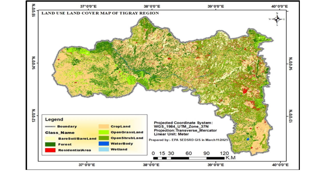
Figure 5: Land Use/Land Cover Map Of The Tigray Region (2025), Illustrating The Spatial Distribution Of Cropland, Forest, Shrub Land, Bare Soil, Residential Land, Grassland, Water Bodies, And Wetlands
Vegetation Condition
NDVI analysis indicated severe vegetation degradation, with 76.93% of the landscape classified as sparse vegetation or bare soil. Moderate vegetation covered only 5.54%, dense vegetation 0.34%, and healthy vegetation was virtually absent (0.002%), demonstrating limited ecosystem recovery and high susceptibility to erosion and desertification.
|
Classification |
NDVI Range |
Area (km²) |
Percent |
|
Water/Settlement/Non-vegetated |
-0.199 to 0.201 |
87,259.29 |
1719% |
|
Sparse vegetation/Bare soil |
0.202 to 0.252 |
390,576.82 |
7693% |
|
Cropland/Moderate vegetation |
0.253 to 0.322 |
28,134.78 |
554% |
|
Dense vegetation |
0.323 to 0.434 |
1,729.08 |
0.341 |
Table 7: NDVI Classification and Vegetation Cover in The Tigray Region
Soil Condition
Soil pH exhibited considerable spatial variability. Slightly to moderately acidic soils occupied 54.03% of the region, neutral soils 30.95%, and alkaline soils 15.03%, indicating the need for site-specific soil restoration and nutrient management strategies.
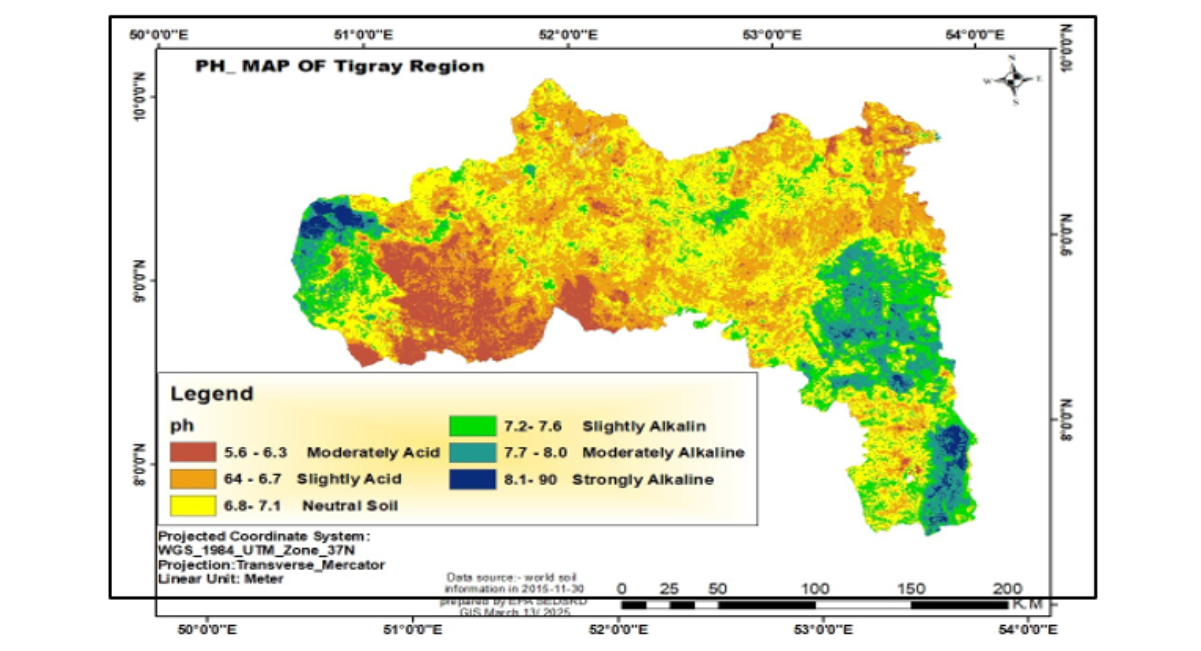
Figure 6 : Spatial Distribution of Soil Ph Across the Tigray Region
|
pH Range |
Soil Class |
Area (ha) |
Percent |
|
5.6–6.3 |
Moderately acidic |
535,456.14 |
1061% |
|
6.4–6.7 |
Slightly acidic |
2,191,829.97 |
4342% |
|
6.8–7.1 |
Neutral |
1,562,199.48 |
3095% |
|
7.2–7.6 |
Slightly alkaline |
539,897.67 |
1070% |
|
7.7–8.0 |
Moderately alkaline |
184,243.37 |
3.66 |
|
8.1–9.0 |
Strongly alkaline |
34,121.68 |
0.67 |
Table 8 : Soil pH Distribution in the Tigray Region
Hydrological Condition
Surface water resources remain scarce, with rivers largely seasonal and wetlands covering less than 0.05% of the landscape. Vegetation loss has accelerated runoff, soil erosion, and sediment transport, with estimated erosion rates of 30–90 t ha⁻¹ yr⁻¹ threatening watershed stability and downstream water resources.
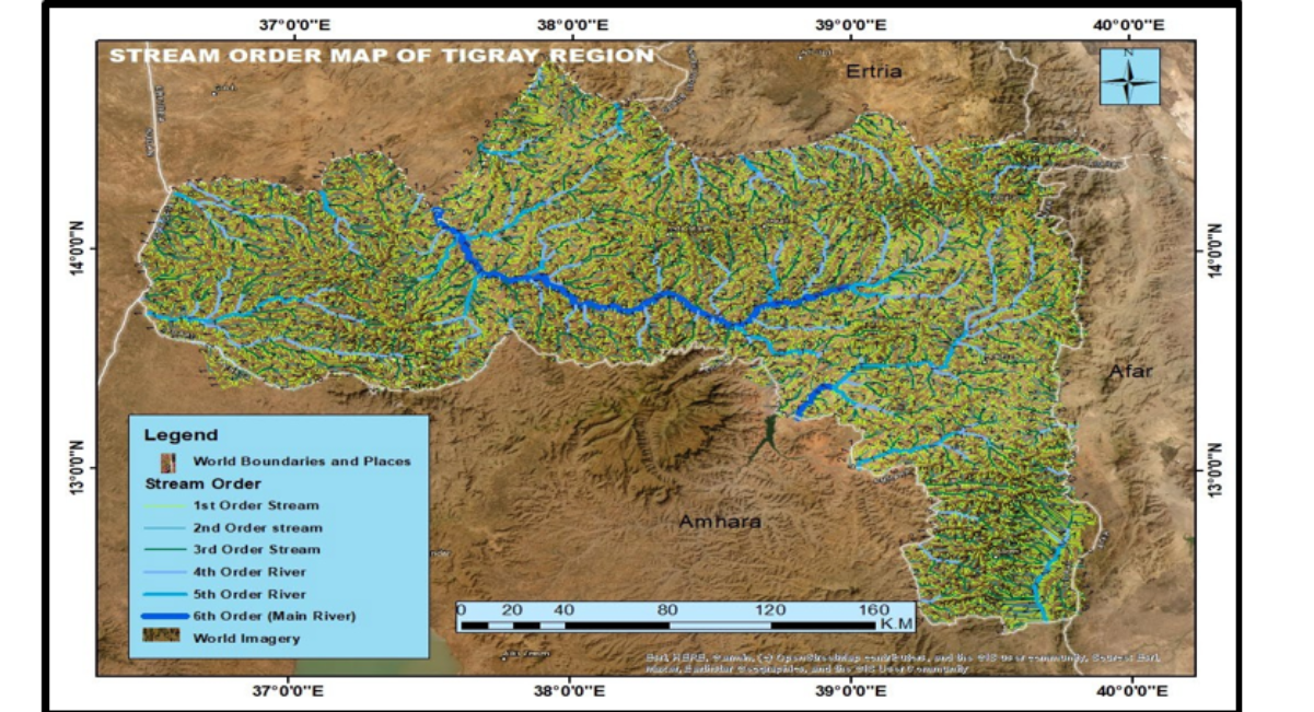
Figure 7: Watershed Delineation and Stream Network of the Tigray Region Showing Major Drainage Systems and Hydrological Connectivity
Environmental and Socio-economic Impacts
The cumulative environmental degradation has substantially reduced ecosystem services and increased socio-economic vulnerability. Agricultural productivity is increasingly constrained by vegetation loss, declining soil quality, erosion, and rainfall variability despite cropland covering nearly 40% of the landscape. Simultaneously, limited surface water resources, declining groundwater recharge, and inadequate watershed management have intensified regional water insecurity, reducing water availability for domestic use, irrigation, and ecosystem maintenance. Human health risks are supposed to increase through multiple exposure pathways. Mercury contamination associated with ASM increases the risks of neurological disorders, renal dysfunction, respiratory disease, and cancer, while widespread damage to water, sanitation, and hygiene (WASH) infrastructure has elevated the incidence of waterborne diseases. Extensive habitat degradation, reflected by extremely limited dense vegetation cover (0.34%), has further reduced biodiversity and weakened ecosystem services supporting watershed stability and climate regulation.
Environmental degradation also contributes to climate change through declining carbon sequestration and increasing greenhouse gas emissions. Total emissions are projected to increase from 7.34 Mt CO₂e in 2010 to 28.74 Mt CO₂e by 2045, with agriculture and forestry remaining the dominant emission sources. Industrial and transport emissions are projected to increase most rapidly, highlighting the need for integrated low-carbon development strategies.
|
Sector |
2010 |
202000% |
2030 |
2040 |
2045 |
|
Agriculture |
3.82 |
643% |
9.05 |
11.67 |
12.97 |
|
Forestry |
2.69 |
355% |
4.4 |
5.26 |
5.69 |
|
Transport |
0.15 |
105% |
1.96 |
2.86 |
3.31 |
|
Industry |
0.20 |
181% |
3.42 |
5.04 |
5.85 |
|
Buildings |
0.24 |
0.37 |
0.49 |
0.61 |
0.67 |
|
Total |
7.34 |
13.45 |
19.57 |
25.68 |
28.74 |
Table 9 : Projected Sectoral Greenhouse Gas Emissions in Tigray (Mt CO₂E)
Current Responses and Institutional Capacity
Environmental recovery efforts remain limited and fragmented, with interventions primarily focused on humanitarian assistance rather than ecosystem restoration [26]. Existing initiatives—including the Sustainable Land Management Programme, watershed rehabilitation, participatory forest management, farmer-managed natural regeneration, agroforestry, and cooperative ASM programmes have demonstrated localized improvements in vegetation recovery, soil conservation, and water management [52]. However, these interventions remain insufficient to address the scale of post-conflict environmental degradation across the basin. Institutional recovery continues to be constrained by fragile governance arrangements, overlapping institutional mandates, weak regulatory enforcement, inadequate environmental monitoring, and limited financial, technical, and human resources. In addition, climate adaptation, gender integration, and rural institutional development remain poorly incorporated into basin management, limiting long-term environmental resilience.
Priority Environmental and Climate Issues for Basin Planning
The DPSIR assessment identified eight interrelated priority themes that should be integrated into the Tekeze River Basin Plan to address the underlying drivers of environmental degradation while strengthening ecosystem resilience and climate adaptation.
Ecosystem Restoration and Sustainable Land Management
Priority actions should focus on reversing recent deforestation (403 km²), restoring degraded landscapes characterized by sparse vegetation (76.93%), rehabilitating riparian corridors and degraded watersheds, and implementing integrated soil conservation measures to address widespread soil acidity (54.03%) and declining land productivity.
Integrated Water Resources Management
Water resource planning should prioritize increasing water security in a basin where surface water covers only 0.40% of the landscape, while addressing water quality deterioration, watershed degradation, sedimentation, and unsustainable water resource utilization.
Sustainable Artisanal and Small-Scale Mining
Priority interventions should promote formalization and environmental regulation of ASM, reduce mercury and cyanide use, prevent contamination of water, soil, and air resources, and minimize associated public health risks.
Climate Change Adaptation and Mitigation
Climate strategies should strengthen resilience to increasing droughts, floods, and landslides while reducing greenhouse gas emissions, particularly from agriculture (52%) and forestry (37%), to mitigate the projected four-fold increase in emissions by 2045.
Waste Management and Pollution Control
Environmental management should restore municipal solid waste services, strengthen industrial effluent regulation, and improve healthcare waste management to reduce environmental pollution and associated health risks.
Gender Equality and Social Inclusion
Basin planning should mainstream gender-responsive approaches by addressing high female illiteracy (44.87%), expanding women's economic and leadership opportunities, and reducing their disproportionate vulnerability to climate and environmental shocks.
Sustainable Rural Livelihoods
Priority investments should improve rural access to electricity and sanitation while promoting climate-resilient agriculture, sustainable natural resource management, and diversified livelihood opportunities to strengthen household resilience.
Institutional Strengthening and Environmental Governance
Effective implementation requires strengthening institutional coordination, establishing environmental monitoring networks, improving legal and regulatory enforcement, and enhancing human, technical, and financial capacities to support evidence-based basin management.
Implementation Roadmap
A phased implementation strategy is proposed to operationalize the environmental and climate priorities identified in the DPSIR assessment.
Phased Implementation
Implementation is organized into five sequential phases over 15 years. Phase 1 (Years 1–3) establishes enabling policies, institutional reforms, climate-smart agriculture, and environmental safeguards. Phase 2 (Years 4–6) prioritizes environmental infrastructure, monitoring systems, and regulatory enforcement. Phase 3 (Years 7–9) scales up renewable energy, ecosystem restoration, waste management, and sustainable industrial development. Phase 4 (Years 10–12) advances circular economy practices, environmental compliance, and mining rehabilitation. Phase 5 (Years 13–15) consolidates sustainability through universal environmental services, renewable energy expansion, rural electrification and sanitation, greenhouse gas mitigation, and elimination of illegal mining.
|
Phase |
Period |
Focus |
Key Activities |
|
Phase 1 |
Years 1-3 |
Foundation Building |
Establish legal frameworks, institutional structures, gender mainstreaming, land certification, risk containment; ban untreated wastewater; begin rural livelihood improvements;implement climate-smart agriculture; establish mining regulations |
|
Phase 2 |
Years 4-6 |
Infrastructure Development |
Build waste treatment facilities, establish monitoring networks, implement ESIA systems; empower inspection squads; establish environmental courts; strengthen mining monitoring |
|
Phase 3 |
Years 7-9 |
System Expansion |
Scale up renewable energy, establish waste-to-energy plants, develop eco-industrial parks; establish monitoring stations; achieve buffer zone planting; strengthen mining enforcement |
|
Phase 4 |
Years 10-12 |
Advanced Implementation |
Achieve 90% circular economy targets, establish advanced material recovery facilities; achieve 80% industry monitoring; implement mining remediation |
|
Phase 5 |
Years 13-15 |
Sustainability |
Achieve 100% targets, consolidate institutions; achieve rural electrification (80% on-grid, 20% off-grid); 100% rural sanitation; 90% renewable energy; 100% GHG reduction; zero illegal mining |
Table 10 : Phased Implementation Timeline
Financing Framework
Long-term implementation requires coordinated financing from federal and regional governments, local authorities, international development partners, climate finance mechanisms, private-sector investment, and an Environmental Trust Fund to ensure sustainable implementation of the basin plan.
|
Source |
Mechanism |
Target Allocation |
|
Federal Government |
Budget allocation |
2% of federal project |
|
Regional Government |
Regional budget |
2% of regional budget |
|
Woreda and municipalities |
Environmental infrastructure |
15% of allocation |
|
International Partners |
Grants and loans |
$500 million over 15 years |
|
Green Climate Fund |
Climate projects |
$100 million over 10 years |
|
Private Sector |
Green investments |
$200 million over 15 years |
Table 11 : Financing Sources
The Integrated Conflict-Sensitive Environmental and Social Safeguarding (ICSESS) Framework
Framework Overview
The Integrated Conflict-Sensitive Environmental and Social Safeguarding (ICSESS) framework provides a phased, systems-based pathway for post-conflict environmental recovery and sustainable basin management [9]. The framework integrates, a 15-year logical framework, and five sequential implementation phases to mainstream environmental sustainability, resilience, and circular economy principles into the basin plan. The long-term goal is to establish integrated environmental management systems that safeguard ecosystems while supporting a circular economy. The anticipated impact is a resilient, green, and inclusive development pathway that promotes environmental security, sustainable livelihoods, and economic transformation after 15 years [9]. The framework is operationalized through six strategic objectives: (i) sustainable investment systems, (ii) waste-to-resource transformation, (iii) green urban development, (iv) disaster risk reduction, (v) ecosystem conservation, and (vi) institutional strengthening.
Framework Components
The ICSESS framework comprises six mutually reinforcing components: (i) conflict-sensitive environmental safeguarding based on the Do No Harm principle, environmental security, and peace building; (ii) environmental safeguards through ESIA, SESA, SEMS, and RPF; (iii) climate change integration combining seven adaptation pillars and six mitigation pillars to strengthen resilience and reduce emissions; (iv) gender mainstreaming through gender-responsive indicators, women's leadership, equitable resource access, and green entrepreneurship; (v) rural livelihood enhancement by expanding universal sanitation and electricity access, sustainable natural resource use, and green rural enterprises; and (vi) institutional strengthening through establishment of specialized environmental institutions and courts, accredited laboratories, real-time environmental monitoring systems, strengthened inspection capacity, and green certification of regulated sectors. Together, these components provide an integrated governance framework for conflict-sensitive environmental restoration and long-term sustainable development [9].
DISCUSSION
Environmental Transformation of Post-Conflict River Basins
The findings demonstrate that environmental degradation in post-conflict river basins is not simply the cumulative outcome of isolated environmental disturbances but the result of interacting socio-ecological processes triggered by armed conflict, institutional collapse, climate change, and unsustainable resource exploitation. The DPSIR assessment illustrates how conflict functions as a systemic driver that simultaneously weakens environmental governance, accelerates resource extraction, disrupts ecosystem services, and reduces institutional capacity to respond. Rather than representing temporary disturbances, these processes fundamentally transform watershed functioning by creating reinforcing feedbacks between ecological degradation, weakened governance, and socio-economic vulnerability. The rapid reversal of nearly two decades of watershed rehabilitation, evidenced by the loss of 403 km² of vegetation [38,42], illustrates the fragility of restoration gains in conflict-affected landscapes. The predominance of sparse vegetation and bare soil (76.93%) [9] Indicates that ecosystem degradation has progressed beyond localized land-cover change to landscape-scale deterioration, with implications for hydrological regulation, soil conservation, biodiversity, and long-term watershed resilience [51]. These findings support the growing recognition that post-conflict environmental degradation should be viewed as a coupled socio-ecological transformation rather than a collection of sector-specific environmental problems.
Similarly, the widespread contamination associated with damaged industrial facilities and the rapid expansion of chemical-based artisanal and small-scale mining (ASM) reflects the breakdown of environmental governance rather than isolated pollution events. Conflict-related damage at Sheba Tannery and Almeda Textile has transformed industrial sites into persistent pollution sources through the release of hexavalent chromium [Cr(VI)], sodium sulfide, heavy metals, and synthetic dyes into interconnected river systems [35,46]. Concurrently, weakened regulatory oversight has accelerated informal mining and the use of mercury and cyanide, increasing contamination risks across terrestrial and aquatic ecosystems [17,18,25,44,54]. Together, these findings demonstrate that post-conflict environmental recovery requires restoring environmental governance as much as restoring degraded ecosystems.
The collapse of municipal waste management and healthcare waste systems further illustrates how institutional disruption amplifies environmental and public health risks. Inadequately managed municipal wastes, untreated healthcare wastes, and damaged environmental infrastructure create persistent contamination pathways that extend beyond immediate humanitarian concerns. Climate change acts as a risk multiplier, increasing the likelihood that degraded ecosystems will experience recurrent droughts, floods, landslides, and declining ecosystem resilience [9]. Consequently, post-conflict environmental recovery should be understood as a long-term resilience challenge requiring integrated ecological, institutional, and socio-economic interventions rather than isolated infrastructure rehabilitation.
Environmental Mainstreaming as the Missing Dimension of River Basin Planning
The findings highlight an important limitation of conventional Integrated River Basin Management (IRBM) in conflict-affected regions. Traditional basin planning primarily emphasizes water allocation, hydrological infrastructure, and resource development under assumptions of institutional stability, effective governance, and functioning environmental monitoring systems. These assumptions rarely hold in post-conflict settings, where governance institutions are weakened, environmental information is scarce, and multiple sectors simultaneously experience systemic failure.
The DPSIR assessment demonstrates that environmental degradation within the Tekeze River Basin extends well beyond water-resource management. Industrial contamination, chemical-intensive mining, healthcare waste, municipal pollution, biodiversity loss, land degradation, climate vulnerability, and weakened environmental governance interact across sectors and administrative boundaries, producing cumulative impacts that cannot be effectively addressed through conventional basin planning approaches alone. These interconnected pressures illustrate why environmental mainstreaming should become a foundational component of basin planning rather than a complementary environmental safeguard. Integrating environmental considerations into river basin planning provides multiple benefits beyond ecosystem protection. Environmental mainstreaming enables planners to identify priority restoration areas, evaluate cumulative environmental risks, coordinate investments across sectors, strengthen institutional accountability, and incorporate climate adaptation, disaster risk reduction, and social inclusion into long-term development strategies. Consequently, river basin planning evolves from a predominantly water-management exercise toward an integrated socio-ecological planning framework capable of supporting sustainable recovery in fragile environments.
ICSESS as a Decision-Support Framework for Basin Planning
A major contribution of this study is the integration of the Driver–Pressure–State–Impact–Response (DPSIR) framework with the proposed Integrated Conflict-Sensitive Environmental and Social Safeguarding (ICSESS) framework. These frameworks perform complementary rather than overlapping functions. DPSIR provides the analytical foundation by systematically identifying environmental drivers, pressures, ecosystem conditions, impacts, and potential responses. However, DPSIR alone does not specify how identified priorities should be translated into coordinated implementation, investment sequencing, institutional reforms, or long-term environmental governance.
The ICSESS framework addresses this implementation gap by operationalizing DPSIR outputs within a phased 15-year basin planning strategy. The framework translates environmental diagnosis into practical decision-making through coordinated interventions spanning ecosystem restoration, pollution control, climate adaptation and mitigation, environmental safeguards, sustainable mining governance, institutional strengthening, gender-responsive planning, and livelihood diversification. In this way, ICSESS functions as a decision-support framework that enables basin authorities or equivalents to prioritize investments, sequence restoration activities, establish measurable performance indicators, strengthen inter-sectoral coordination, and implement adaptive environmental management. Unlike conventional environmental safeguard frameworks that focus primarily on project-level compliance, ICSESS embeds environmental sustainability directly within basin governance and reconstruction planning. The framework therefore bridges the long-recognized gap between environmental assessment and environmental implementation by providing an operational pathway through which scientific evidence can inform policy, investment, and adaptive management. This integration represents the principal conceptual innovation of the study and advances environmental mainstreaming from a planning principle to an implementable basin management strategy.
LIMITATIONS AND FUTURE RESEARCH
Several limitations should be acknowledged. First, the study assessed only the Tigray-administered portion of the Tekeze River Basin that was accessible during the study period. Owing to security and administrative constraints, the current environmental conditions of the Western Tigray section could not be assessed, and analyses for this area relied solely on available pre-conflict information. Consequently, the reported findings may underestimate the full extent of post-conflict environmental degradation across the entire basin. Second, field investigations were conducted under continuing security constraints, limiting site accessibility and the completeness of environmental observations. Third, the limited availability of comprehensive pre-conflict environmental datasets constrained quantitative attribution of conflict-related environmental change. Fourth, although assessments covered the principal urban centres within the accessible basin, environmental conditions in some remote rural areas may remain underrepresented. Finally, security concerns prevented direct investigation of several artisanal and small-scale mining sites, limiting detailed characterization of contamination pathways [25].
Future research should extend environmental assessments to the currently inaccessible Western Tigray section once conditions permit, enabling a comprehensive basin-wide evaluation. Additional priorities include establishing long-term environmental monitoring systems integrating remote sensing and field observations, quantifying soil, sediment, groundwater, and ecological contamination associated with industrial pollution and chemical-based artisanal mining, evaluating cumulative public health impacts, assessing the implementation effectiveness of the ICSESS framework, developing cost-effective remediation technologies for mercury- and cyanide-contaminated environments, and investigating the socio-economic drivers of artisanal mining. Such evidence will strengthen adaptive environmental governance and support conflict-sensitive, climate-resilient river basin planning.
CONCLUSION
This study presents the first comprehensive DPSIR-based environmental assessment of the Tekeze River Basin following the 2020–2022-armed conflict and demonstrates that environmental recovery is indispensable for sustainable river basin planning, climate resilience, and long-term ecological peace building. The findings reveal that the interaction of armed conflict, climate change, institutional collapse, and unsustainable resource extraction has generated cascading impacts across terrestrial, aquatic, industrial, and public health systems. Extensive vegetation loss, widespread land degradation, untreated municipal and industrial wastes, deteriorated healthcare waste management, and the rapid expansion of chemical-based artisanal and small-scale mining collectively threaten ecosystem integrity, water security, agricultural productivity, biodiversity, and human well-being [9,25,38,46,49]. Beyond documenting environmental degradation, this study demonstrates that post-conflict environmental recovery is fundamentally governance and socio-ecological systems challenge. Weak institutional capacity, fragmented environmental governance, inadequate monitoring systems, and persistent gender inequalities have reduced adaptive capacity and reinforced environmentally unsustainable livelihood practices [9]. Without integrated and coordinated interventions, these interacting pressures are likely to intensify under increasing climate variability, including more frequent droughts, floods, and landslides, thereby further undermining ecosystem resilience and sustainable development [9].
A major scientific contribution of this research is the development of the Integrated Conflict-Sensitive Environmental and Social Safeguarding (ICSESS) framework, which translates environmental assessment into a practical implementation strategy for post-conflict environmental recovery. By integrating ecosystem restoration, pollution control, climate adaptation and mitigation, sustainable mining governance, institutional strengthening, gender-responsive governance, and livelihood improvement within a phased 15-year implementation pathway, ICSESS moves beyond fragmented sectoral interventions toward an integrated, systems-based approach to environmental recovery. More importantly, this study advances the science and practice of Integrated River Basin Management (IRBM) by demonstrating that post-conflict basin planning should extend beyond conventional water resources management to incorporate environmental restoration, climate resilience, disaster risk reduction, environmental governance, and social inclusion as core planning objectives. The integration of the DPSIR analytical framework with the ICSESS decision-support framework bridges the critical gap between environmental diagnosis and implementation by enabling basin planners to identify priority environmental risks, sequence restoration investments, coordinate cross-sectoral interventions, establish measurable performance indicators, and strengthen adaptive governance. In doing so, the framework transforms environmental assessment from a diagnostic exercise into an operational planning and decision-support system capable of guiding evidence-based basin management.
This study therefore advances both the science and practice of river basin planning by demonstrating that environmental assessment alone is insufficient for effective post-conflict recovery unless linked to an operational implementation framework. By integrating the DPSIR analytical framework with the ICSESS decision-support framework, the study provides a structured pathway for translating environmental evidence into prioritized investments, adaptive governance, ecosystem restoration, and climate-resilient basin planning. Beyond the Tekeze River Basin, the proposed DPSIR–ICSESS framework offers a scalable and transferable model for mainstreaming environmental sustainability into Integrated River Basin Management, supporting post-conflict reconstruction and sustainable development across fragile and conflict-affected river basins worldwide.
POLICY IMPLICATIONS AND RECOMMENDATIONS
The findings underscore that environmental restoration should be a central component of post-conflict reconstruction and integrated river basin management rather than a stand-alone environmental intervention, guided by the DPSIR assessment and the ICSESS framework, four strategic priorities are proposed.
Strategic Priority 1: Strengthen Basin Governance
Institutionalize environmental mainstreaming by adopting DPSIR as the standard basin assessment framework and ICSESS as the implementation platform. Strengthen integrated governance through coordinated institutions with clear mandates, accountability, and cross-sectoral collaboration across water, land, forestry, mining, biodiversity, waste, public health, and climate sectors.
Strategic Priority 2: Restore Environmental Systems.
Prioritize remediation of industrial pollution, hazardous healthcare waste, contaminated mining sites, municipal dumpsites, and unexploded ordnance. Accelerate restoration of wastewater infrastructure, sanitary landfills, healthcare waste treatment systems, degraded watersheds, wetlands, riparian ecosystems, and mine sites while formalizing artisanal mining and strengthening environmental compliance.
Strategic Priority 3: Build Climate and Community Resilience.
Mainstream climate adaptation, greenhouse gas mitigation, climate-smart agriculture, renewable energy, and nature-based solutions into basin planning. Promote gender-responsive governance, equitable access to natural resources and green employment, and diversified climate-resilient livelihoods to enhance social and ecological resilience.
Strategic Priority 4: Support Adaptive Basin Management.
Establish basin-wide environmental intelligence systems integrating remote sensing, laboratory monitoring, standardized indicators, and periodic State of the Environment reporting. Secure long-term implementation through dedicated environmental financing, climate finance, and payment for ecosystem services, supported by continuous monitoring, implementation evaluation, and applied research.
Together, these priorities provide a coherent roadmap for integrating post-conflict environmental recovery into long-term basin planning. The combined DPSIR–ICSESS approach offers a scientifically robust and operationally scalable framework for strengthening ecosystem restoration, environmental governance, climate resilience, and sustainable development in the Tekeze Basin and other conflict-affected river basins.
REFERENCES
- Katusiime J, Schütt B. Integrated water resources management approaches to improve water resources governance. Water. 2020;12(12):3424. [Crossref] [Google Scholar]
- Haddis A, De Geyter A, Smets I, Van der Bruggen B. Wastewater management in Ethiopian higher learning institutions: functionality, sustainability and policy context. Journal of Environmental Planning and Management. 2014;57(3):369-83. [Crossref] [Google Scholar]
- Zhang Q, Zhang X, Li S, Liu H, Liu L, Huang Q et al. Joint effect of urinary arsenic species and serum one-carbon metabolism nutrients on gestational diabetes mellitus: a cross-sectional study of Chinese pregnant women. Environment International. 2021;156:106741. [Crossref] [Google Scholar]
- Wazza M. Ten years development plan of Ethiopia (2021-2030): a critical review. [Crossref] [Google Scholar]
- Tesfaye L, Alemayehu S, Jalango D, Karanja S, Magambo G, Ghosh A, et al. Climate-smart agriculture investment plan for Ethiopia. [Crossref] [Google Scholar]
- Seccatore J, Veiga M, Origliasso C, Marin T, De Tomi G. An estimation of the artisanal small-scale production of gold in the world. Science of the Total Environment. 2014;496:662-7. [Crossref] [Google Scholar] [PubMed]
- Basu N, Renne EP, Long RN. An integrated assessment approach to address artisanal and small-scale gold mining in Ghana. International Journal of Environmental Research and Public Health. 2015;12(9):11683-98. [Crossref] [Google Scholar] [PubMed]
- Quash Y, Kross A, Jaeger JA. Assessing the impact of gold mining on forest cover in the Surinamese Amazon from 1997 to 2019: A semi-automated satellite-based approach. Ecological Informatics. 2024;80:102442. [Crossref] [Google Scholar]
- Chirico PG, Malpeli KC. The role of conflict minerals, artisanal mining, and informal trading networks in African intrastate and regional conflicts. Journal Article| Sep. 2014;18(11):27am. [Crossref] [Google Scholar]
- Elwaleed A, Jeong H, Abdelbagi AH, Thi Quynh N, Nugraha WC, Agusa T, et al. Assessment of mercury contamination in water and soil from informal artisanal gold mining: implications for environmental and human health in Darmali area, Sudan. Sustainability. 2024;16(10):3931. [Crossref] [Google Scholar]
- Liu R, Liu F, Jiao J, Xu Y, Dong Y, RM EW. Potential toxic impacts of Hg migration in the disjointed hyporheic zone in the gold mining area experiencing river water level changes. Water. 2022;14(19):2950. [Crossref] [Google Scholar]
- Nyssen J, Kiros H. Map of Tigray’s mineral resources (north Ethiopia)-Canadian and other international mining licenses.[Crossref] [Google Scholar]
- Meaza H, Ali M, Hishe S, Tesfamariam Z. Small scale gold mining effects on the miners and local communities in semi-arid region of Ethiopia. Journal for Geography. 2015;10(1):25-40. [Crossref] [Google Scholar]
- ABERRA Y. Bibliography and Bibliometry. [Crossref] [Google Scholar]
- Gebru HG, Gebru BM, Siyum ZG, Weldengus GT. Environmental implications of Chemical based artisanal and small scale mining in post war Tigray, Northern Ethiopia. [Crossref] [Google Scholar]
- Abebe HT, Abraha HE, Abrha MM, Tesfay TB, Belay RE, Araya AA. Armed conflict and household food insecurity: evidence from war-torn Tigray, Ethiopia. Conflict and Health. 2023;17(1):22. [Crossref] [Google Scholar]
- Manaye A, Afewerk A, Manjur B, Solomon N. The Effect of the war on smallholder agriculture in Tigray, Northern Ethiopia. Cogent food & agriculture. 2023;9(1):2247696. [Crossref] [Google Scholar]
- Nyssen J, Negash E, Van Schaeybroeck B, Haegeman K, Annys S. Crop cultivation at wartime–plight and resilience of Tigray’s Agrarian Society (North Ethiopia). Defence and peace economics. 2023;34(5):618-45. [Crossref] [Google Scholar]
- Mann ME, Kump LR. Dire predictions. New York. 2015. [Crossref] [Google Scholar]
- Carr ER, Wingard PM, Yorty SC, Thompson MC, Jensen NK, Roberson J. Applying DPSIR to sustainable development. International journal of sustainable development & world ecology. 2007;14(6):543-55. [Crossref] [Google Scholar]
- Awulachew SB, Yilma AD, Loulseged M, Loiskandl W, Ayana M, Alamirew T. Water resources and irrigation development in Ethiopia. Iwmi; 2007. [Crossref] [Google Scholar]
- Fernández‐Calviño D, López‐Periago E, Nóvoa‐Muñoz JC, Arias‐Estévez M. Short‐scale distribution of copper fractions in a vineyard acid soil. Land Degradation & Development. 2008;19(2):190-7. [Crossref] [Google Scholar]
- Rouse Jr JW, Haas RH, Schell JA, Deering DW. Monitoring vegetation systems in the Great Plains with ERTS. InNASA. Goddard Space Flight Center 3d ERTS-1 Symp., Vol. 1, Sect. A 1974 (No. PAPER-A20). [Crossref] [Google Scholar]
- Abate Z. Water resources development in Ethiopia: an evaluation of present experience and future planning concepts. 1994. [Crossref] [Google Scholar]
- Darmian MD, Schmalz B. Application of genetic programming in presenting novel equations for longitudinal dispersion coefficient in natural streams considering rivers geometry-Implementation in assimilation capacity simulation. Journal of Environmental Management. 2023;340:117985. [Crossref] [Google Scholar]
- CLEARING US, RIGHTS L. in Mine Action. [Crossref] [Google Scholar]
- Tsegay B, Gezahegne K. Internal displacement in Ethiopia: Towards a new policy and legal framework for durable solutions. Heinrich Böll Foundation, Nairobi, Kenya. 2023. [Crossref] [Google Scholar]
- Kassa H, Abiyu A, Hagazi N, Mokria M, Kassawmar T, Gitz V. Forest landscape restoration in Ethiopia: Progress and challenges. Frontiers in Forests and Global Change. 2022;5:796106. [Crossref] [Google Scholar]
- Dietz T, Rosa EA, York R. Environmentally efficient well-being: Is there a Kuznets curve?. Applied Geography. 2012;32(1):21-8. [Crossref] [Google Scholar]
- Li RR, Wang BL, Nan FR, Lv JP, Liu XD, Liu Q, et al. Effects of polystyrene nanoplastics on the physiological and biochemical characteristics of microalga Scenedesmus quadricauda. Environmental Pollution. 2023;319:120987. [Crossref] [Google Scholar]
- Aleku DL, Lazareva O, Pichler T. Mercury in groundwater–Source, transport and remediation. Applied Geochemistry. 2024;170:106060. [Crossref] [Google Scholar]
- Gole TW. Peer Review# 2 of" Land use and land cover dynamics and traditional agroforestry practices in Wonchi District, Ethiopia (v0. 1)". [Crossref] [Google Scholar]
- Gibb H, O’Leary KG. Mercury exposure and health impacts among individuals in the artisanal and small-scale gold mining community: a comprehensive review. Environmental health perspectives. 2014;122(7):667-72. [Crossref] [Google Scholar] [PubMed]
- Tadesse D. Study of domestic solid waste management in JIMMA town, southwest Ethiopia. [Crossref] [Google Scholar]
- Theisen H, Vigil SA. Integrated solid waste management: Engineering principles and management issues. McGraw-Hill; 1993. [Crossref] [Google Scholar]
- Gezahegn A, Merga LB, Mammo S. Waste Management Bulletin. [Crossref] [Google Scholar]
- Denekew Y. FOOD, MEDICINE AND HEALTH CARE ADMINISTRATION AND CONTROL AUTHORITY. [Crossref] [Google Scholar]
- Kanyamibwa S. Impact of war on conservation: Rwandan environment and wildlife in agony. Biodiversity & Conservation. 1998;7(11):1399-406. [Crossref] [Google Scholar]
- Smeets E, Weterings R. Environmental indicators: Typology and overview. [Crossref] [Google Scholar]
- Central Statistical Agency. Population and housing census report. [Crossref] [Google Scholar]
- Nyssen J, Poesen J, Moeyersons J, Deckers J, Haile M, Lang A. Human impact on the environment in the Ethiopian and Eritrean highlands—a state of the art. Earth-science reviews. 2004;64(3-4):273-320. [Crossref] [Google Scholar]
- Hagos F, Haileslassie A, Seid A, Ayele G. Reducing reservoir sedimentation through Payment for Ecosystem Services: Case of Malka Wakana Hydropower Dam in the Bale Ecoregion, Ethiopia. [Crossref] [Google Scholar]
- Mohseni S, Zare Mehrjerdi MR, Abdolahi Ezzatabadi M, Mehrabi Boshrabadi H. Irrigation water demand management with emphasis on pricing policy. Water Policy. 2022;24(7):1095-108. [Crossref] [Google Scholar]
- American Public Health Association. Standard methods for the examination of water and wastewater. American Public Health Association.; 1926. [Crossref] [Google Scholar]
- Kaza S, Yao L, Bhada-Tata P, Van Woerden F. What a waste 2.0: a global snapshot of solid waste management to 2050. World Bank Publications; 2018. [Crossref] [Google Scholar]
- Gesesew H, Berhane K, Siraj ES, Siraj D, Gebregziabher M, Gebre YG, et al. The impact of war on the health system of the Tigray region in Ethiopia: an assessment. BMJ Global Health. 2021;6(11):e007328. [Crossref] [Google Scholar] [PubMed]
- World Health Organization. Compendium of WHO and other UN guidance on health and environment. World Health Organization; 2021. [Crossref] [Google Scholar]
- Asgedom AA, Redae GH, Gebretnsae H, Tequare MH, Hidru HD, Gebrekidan GB, et al. Post-war status of water supply, sanitation, hygiene and related reported diseases in Tigray, Ethiopia: A community-based cross-sectional study. International journal of hygiene and environmental health. 2025 ;263:114460. [Crossref] [Google Scholar] [PubMed]
- Gebru AL, Abay TK, Asmerom AT. Post‐conflict challenges and aspirations of Tigray Youth, Ethiopia: A needs assessment and recovery roadmap. African Journal of Political Science and International Relations. 2024;18(3):83-95. [Crossref] [Google Scholar]
- Hansen MC, Potapov PV, Moore R, Hancher M, Turubanova SA, Tyukavina A, et al . High-resolution global maps of 21st-century forest cover change. science. 2013;342(6160):850-3. [Crossref] [Google Scholar] [PubMed]
- Tekle K, Hedlund L. Land-use changes and vegetation dynamics in Ethiopia: implications for carbon sequestration and climate change mitigation. J Arid Environ. 2021;195:104573.
- Abdulai I, Hoffmann MP, Jassogne L, Asare R, Graefe S, Tao HH, et al. Variations in yield gaps of smallholder cocoa systems and the main determining factors along a climate gradient in Ghana. Agricultural Systems. 2020;181:102812. [Crossref] [Google Scholar]
- Hailu Tesfaye A, Kabito GG, Gelaye KA, Eyachew D, Dessie A, Hussein N, et al. Access to safe sanitation services and factors associated with personal protective equipment utilisation among sanitation workers in Ethiopia: a mixed-methods study. BMJ open. 2026;16(8):e116558. [Crossref] [Google Scholar]
- Mitiku K. Sensitivity of Streamflow to Meteorological Drought in the Andit Tid watershed, Ethiopia. [Crossref] [Google Scholar]
- Breiman L. Random Forests Mach Learn 45 (1): 5–32. ed. 2001. [Crossref] [Google Scholar]
- Congalton RG, Green K. Assessing the accuracy of remotely sensed data: principles and practices. CRC press; 2008. [Crossref] [Google Scholar]
- Drusch M, Del Bello U, Carlier S, Colin O, Fernandez V, Gascon F, et al. Sentinel-2: ESA's optical high-resolution mission for GMES operational services. Remote sensing of Environment. 2012;120:25-36. [Crossref] [Google Scholar]
- Didan K. MOD13Q1 MODIS/Terra vegetation indices 16-day L3 global 250m SIN grid V006. NASA EOSDIS Land Processes Distributed Active Archive Center (DAAC) data set. 2015:MOD13Q1-006. [Crossref] [Google Scholar]
- Verbesselt J, Hyndman R, Newnham G, Culvenor D. Detecting trend and seasonal changes in satellite image time series. Remote sensing of Environment. 2010;114(1):106-15. [Crossref] [Google Scholar]
- Verbesselt J, Zeileis A, Herold M. Near real-time disturbance detection using satellite image time series. Remote Sensing of Environment. 2012;123:98-108. [Crossref] [Google Scholar]
- Braun V, Clarke V. Using thematic analysis in psychology. Qualitative research in psychology. 2006;3(2):77-101. [Crossref] [Google Scholar]

Article Processing Timeline
| 2-5 Days | Initial Quality & Plagiarism Check |
| 25-35 Days |
Peer Review Feedback |
| 45-60 Days | Total article processing time |
Why Publish with us?
Ethics & Policies
Editorial & Management
Useful Links
Journal Highlights
Open Access Journals
Journal Flyer