


Journal of Climate Change and Pollution
ISSN:
3108-2025 (Online)
DOI Prefix (Crossref): 10.67238
 Download PDF

Department of Environmental Sciences, Government Boys Degree College Zhob, Zhob, Pakistan
ABSTRACT
Water scarcity, climate variability, and land degradation are among the principal environmental challenges affecting arid and semi-arid regions of Balochistan, Pakistan. In recent years, agricultural expansion along the upper bank of the Zhob River has increased due to improved groundwater availability associated with the Sabakzai Dam and the adoption of solar-powered irrigation systems. This case study examines how groundwater recharge, supported by river flow and reservoir storage, has contributed to the conversion of previously barren land into productive agricultural fields. The study integrates field observations, Global Positioning System (GPS) surveys, Geographic Information System (GIS) mapping, and local community information to evaluate agricultural expansion within the study area. The research also investigates the contribution of solar-powered tube wells to sustainable irrigation by reducing dependence on diesel-powered pumping systems and lowering production costs. Findings from field observations indicate that increased groundwater availability has supported the establishment of orchards and vegetable cultivation, including apples, apricots, almond, tomato, onion, and garlic. The study demonstrates that the combined influence of Sabakzai Dam, the Zhob River, and renewable energy technologies has enhanced agricultural productivity, strengthened climate resilience, and improved rural livelihoods. The findings highlight the importance of integrated water resource management and nature-based approaches for sustainable agricultural development in the semi-arid landscapes of northern Balochistan.
Keywords: Agricultural Restoration; Zhob River; Sabakzai Dam; Groundwater Recharge; Solar Irrigation; GIS; GPS; Climate Change Adaptation; Nature-Based Solutions; Sustainable Agriculture; Balochistan; Pakistan
INTRODUCTION
Climate change has emerged as one of the greatest environmental challenges of the twenty-first century, particularly in arid and semi-arid regions where water resources are naturally scarce.
Rising temperatures, prolonged droughts, changing precipitation patterns, groundwater depletion, and increasing frequency of extreme climatic events threaten agricultural productivity, food security, and rural livelihoods worldwide [1]. Pakistan is among the countries most vulnerable to climate change due to its dependence on climate-sensitive sectors, especially agriculture and water resources. Northern Balochistan is particularly susceptible because agriculture relies predominantly on groundwater abstraction through tube wells and seasonal river flows, while declining groundwater levels continue to threaten long-term agricultural sustainability.
Nature-based solutions (NbS) have gained global recognition as effective approaches for addressing climate change while enhancing ecosystem resilience and supporting sustainable development. These solutions utilize natural processes to mitigate environmental degradation, improve water security, restore ecosystems, and strengthen climate adaptation. In water-limited environments, rivers, reservoirs, groundwater recharge, watershed management, and sustainable land-use practices collectively contribute to ecosystem restoration and improved agricultural productivity. Integration of these approaches with renewable energy technologies, particularly solar-powered irrigation systems, further promotes sustainable agriculture by reducing greenhouse gas emissions and dependence on fossil fuels while improving irrigation efficiency [1].
The upper bank of the Zhob River in District Zhob has experienced considerable agricultural transformation following improvements in water availability associated with the construction of the Sabakzai Dam. The reservoir has enhanced groundwater recharge in adjacent areas, increasing groundwater availability for irrigation through tube wells. Consequently, land that was previously barren or sparsely vegetated has gradually been converted into productive agricultural fields and orchards. Farmers have increasingly adopted solar-powered pumping systems, reduced irrigation costs while ensuring reliable water access throughout the year. These developments represent an important example of local climate adaptation through integrated water resource management, groundwater utilization, and renewable energy technologies.
The study area now supports diversified agricultural production, including apple (Malus domestica), apricot (Prunus armeniaca), almond (Prunus dulcis), tomato (Solanum lycopersicum), onion (Allium cepa), garlic (Allium sativum), and several other seasonal crops. Expansion of irrigated agriculture has enhanced household incomes, created employment opportunities, strengthened local food security, and reduced pressure on surrounding rangelands. Such landscape restoration demonstrates the importance of integrated water management in improving ecosystem services and strengthening climate resilience within semi-arid environments [2].
Although previous studies have investigated groundwater resources, irrigation systems, climate change, and agricultural development in Pakistan, relatively limited research has examined the combined influence of river systems, reservoirs, groundwater recharge, and solar-powered irrigation on agricultural restoration in northern Balochistan. This study addresses the knowledge gap by documenting field observations from the upper bank of the Zhob River and evaluating the contribution of the Sabakzai Dam to sustainable agricultural development. Furthermore, it demonstrates the value of integrating Global Positioning System (GPS) surveys, Geographic Information System (GIS) mapping, field observations, and local knowledge to assess landscape transformation and support evidence-based environmental management.
Study Area
Geographic Location
The study was conducted along the upper bank of the Zhob River, extending from Badinzai to the Sabakzai Dam in District Zhob, northern Balochistan, Pakistan. The study area is located approximately between 30.89°–31.18° N latitude and 69.27°–69.38° E longitude, covering nearly 184.65 km² (approximately 18,465 hectares) of agricultural land and formerly barren terrain. The area lies within the upper Zhob River catchment and is accessible via the National Highway (N-50), which runs parallel to the right bank of the Zhob River. The study area encompasses the settlements of Badinzai, Mina Bazar, Yaqoob Zai, the agricultural lands surrounding the Sabakzai Dam, and adjacent farming communities (Figure 1).
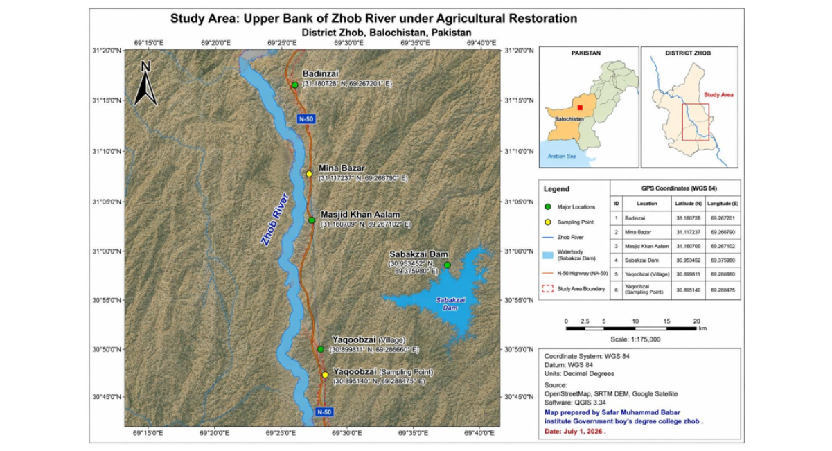
Figure 1: Major Locations in The Study Area
Sabakzai Dam (The Principal Water Reservoir)
The Sabakzai Dam is a medium-sized multipurpose earth- and rock-fill embankment dam constructed across the Sawar Rud, a tributary of the Zhob River, in District Zhob, Balochistan. The project was developed to improve water availability for irrigation, enhance groundwater recharge, reduce flood damage, and support sustainable agricultural development in the semi-arid region of northern Balochistan [3-4].
Construction of the dam began in the early 2000s, and the project was inaugurated in 2007, while development of the irrigation command area continued after completion. The dam has a gross storage capacity of approximately 32,000 acre-feet (about 39.5 million m³) and is designed to irrigate about 8,000 acres (about 3,237.5hectares) of agricultural land through its command area. According to WAPDA project information, the dam is approximately 395 m long and 34.75 m high, making it one of the major water-resource projects in Zhob District [3-4].
The primary objectives of Sabakzai Dam include storing seasonal runoff, reducing downstream flood risk, improving groundwater recharge, increasing irrigation water availability, and supporting agricultural productivity in the surrounding communities. The reservoir has contributed to the expansion of cultivated land, improved water security for farmers, and enhanced resilience against recurring droughts, making it an important climate adaptation measure in this water-scarce region [4].
The Zhob River and seasonal streams flow are the surface water source in the study area, while the Sabakzai Dam (Figure-2) and its canals constructed across the river, serves as the principal and most important water-storage structure that supports groundwater recharge in the surrounding alluvial aquifer. Improved groundwater availability has facilitated the expansion of irrigated agriculture through tube wells, many of which are now powered by solar energy systems. Consequently, extensive areas that were previously barren or sparsely vegetated have been transformed into productive agricultural fields and fruit orchards, illustrating the combined role of surface water storage, groundwater recharge, and renewable energy in enhancing agricultural sustainability and climate resilience.
The elevation of the study area ranges from approximately 1,250 to 1,500 m above sea level, characterized by gently undulating alluvial plains bordered by low mountain ranges. The region has an arid to semi-arid climate, with hot summers, cold winters, low annual precipitation, and high evapotranspiration rates, making agriculture highly dependent on irrigation and groundwater resources [5-6].
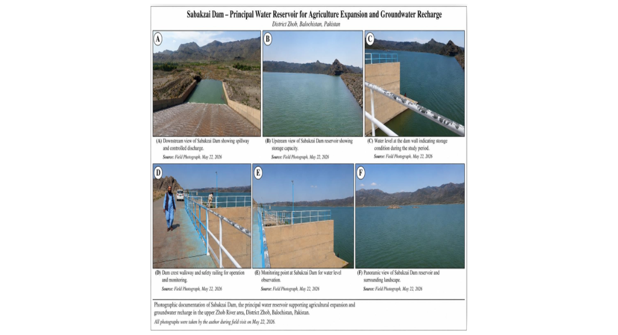
Figure 2: Sabakzai Dam
Climate
District Zhob experiences a semi-arid continental climate characterized by hot summers, cold winters, and low annual precipitation. Summer temperatures frequently exceed 35–37°C, while winter temperatures occasionally fall below 0°C. Most precipitation occurs during the winter due to western disturbances, with limited rainfall received during the summer monsoon season.
Rainfall is generally scarce and highly variable, making agriculture largely dependent on irrigation. High evapotranspiration rates further increase crop water requirements throughout the growing season [4,7].
Recent climatic variability, including prolonged droughts and irregular rainfall patterns, has intensified pressure on groundwater resources across northern Balochistan. Consequently, sustainable groundwater management and climate adaptation measures have become increasingly important for maintaining agricultural productivity and water security [7].
Hydrology
The Zhob River forms the principal surface water system within the study area and plays a significant role in groundwater recharge. Seasonal runoff infiltrates the alluvial deposits along the riverbanks, replenishing the underlying aquifers. The construction of Sabakzai Dam, completed in 2007 on the Sawar Rud (a tributary of the Zhob River), has substantially increased surface water storage and enhanced groundwater recharge in surrounding agricultural lands [7].
Studies have reported that groundwater levels have gradually improved following the construction of the dam, allowing previously uncultivated land to be converted into productive farmland and supporting agricultural expansion. Groundwater remains the principal source of irrigation in the district and is extracted through tube wells and boreholes operated using electric, diesel, and increasingly solar-powered pumping systems [4,7].
Land Use and Agriculture
Historically, much of the Zhob study area consisted of barren or sparsely vegetated land because of limited water availability. The development of groundwater resources and improved irrigation infrastructure, particularly following the construction of Sabakzai Dam, has facilitated the gradual conversion of these lands into productive agricultural fields and orchards [7].
Agriculture is one of the principal sources of livelihood in Zhob District. Major fruit crops include apple (Malus domestica), apricot (Prunus armeniaca), almond (Prunus dulcis), and grapes, while the main vegetable crops include tomato (Solanum lycopersicum), onion (Allium cepa), garlic (Allium sativum), potato, and chilies. Crop production varies according to seasonal climatic conditions and irrigation water availability [4].
Agricultural development has significantly improved local livelihoods through increased farm income, employment generation, and enhanced food security. Recent studies have shown that irrigated agriculture around Sabakzai Dam has contributed to poverty reduction and improved socioeconomic conditions in surrounding communities [7-8].
Renewable Energy and Irrigation
Field observations indicate that the adoption of solar-powered irrigation systems has increased considerably across the study area. Farmers are gradually replacing diesel-powered pumping systems with photovoltaic (PV)-powered tube wells to reduce fuel costs, improve irrigation efficiency, and ensure reliable daytime water supply.
Solar-powered irrigation offers several environmental and economic benefits, including:
- Reduced dependence on fossil fuels.
- Lower greenhouse gas emissions.
- Reduced irrigation and operating costs.
- Improved energy efficiency.
- Reliable daytime water supply.
- Enhanced sustainability of groundwater extraction.
The combined use of groundwater recharge provided by the Zhob River and Sabakzai Dam together with renewable energy technologies represents an effective climate adaptation strategy. This integrated approach supports sustainable agricultural development by improving water-use efficiency, reducing production costs, and strengthening resilience to climate variability in the semi-arid environment of northern Balochistan [7].
MATERIALS AND METHODS
Research Design
A field-based case-study methodology was adopted to assess agricultural restoration along the upper bank of the Zhob River in relation to the Sabakzai Dam, groundwater availability, irrigation development, and agricultural expansion. The study integrated Global Positioning System (GPS) surveying, mobile GIS applications, Geographic Information System (GIS) analysis, satellite-image interpretation, field observations, photographic documentation, groundwater-depth observations, and land-use assessment.
The methodology was designed to evaluate the spatial transformation of previously barren or sparsely vegetated land into agricultural fields and orchards and to examine the relationship between agricultural development, groundwater availability, irrigation infrastructure, vegetation cover, and environmental restoration.
The principal assessment indicators were:
- Agricultural land expansion;
- Vegetation and green-cover condition;
- Groundwater availability;
- Irrigation-source distribution;
- Crop and orchard diversity;
- Spatial relationships among the Zhob river, Sabakzai dam, agricultural land and sampling locations.
Study Area Delineation
The study boundary was delineated using GPS coordinates collected during field surveys and subsequently digitized in a GIS environment. The study extends from the Badinzai area through the agricultural corridor along the upper bank of the Zhob River toward the Sabakzai Dam.
The total study area was calculated as 184.65 square kilometers (18,465 hectares). Within this area, approximately 2,230 hectares were identified as agricultural land, while the remaining area consisted primarily of barren/uncultivated land, rocky terrain, rangelands, and natural vegetation. The study area boundary and major geographical features were mapped using GIS.
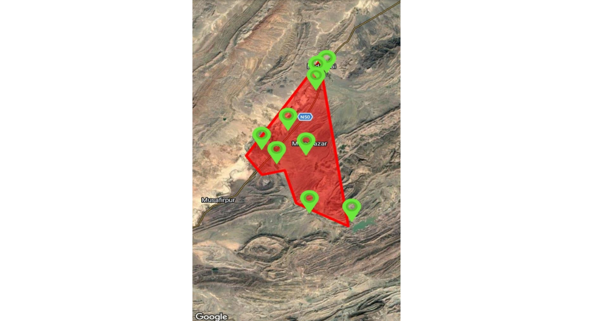
Figure 3: Total Study Area Measurement Cultivated & Barren
Materials, Equipment and Software
The field survey and spatial analysis used the following materials and tools:
- Smartphone with GPS/GNSS capability;
- Gland Go mobile GPS/GIS application for field positioning and coordinate recording;
- Tracklia mobile GPS application for GPS track and route recording;
- Locus GIS mobile application for field-based GIS visualization and spatial management;
- QGIS desktop GIS software for spatial analysis, digitization, area calculation, GPS-point mapping, and preparation of thematic maps;
- Google Satellite imagery for visual interpretation of land-use and land-cover features;
- 54GPS coordinates and field observation records;
- Field photographs; and
- Existing spatial/reference data relevant to roads, river systems, irrigation infrastructure, settlements, and the study boundary.
The GPS data were recorded using the World Geodetic System 1984 (WGS84), EPSG:4326, coordinate reference system.
GPS Survey and Sampling Design
A purposive sampling technique was used to select representative locations within the study area. The sampling design was intended to capture variation in agricultural development, irrigation sources, groundwater conditions, vegetation, riverbank agriculture, and land restoration.
Field surveys were conducted between January and July 2026, covering three seasonal periods: winter, spring, and summer/monsoon. Ten sampling points designated SP-1 to SP-10, were established throughout the study area as shown in figure -4 and coordinates were fixed of these points under research as in table-1.
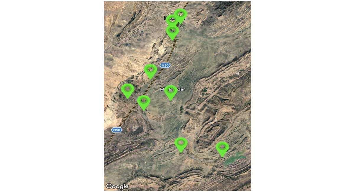
Figure 4: Sampling Points & GPS Coordinates
The selected locations included the Sabakzai Dam area, agricultural fields, orchards, riverbank agricultural areas, solar-powered tube-well areas, groundwater-dependent farms, dam-command areas, and locations where barren land had been converted into agricultural land. At each sampling point, the following information was recorded:
1)Latitude and longitude (2) Land-use type (3) agricultural status (4) Crop and orchard type (5) Vegetation condition (6) Irrigation source (7) Presence of solar-powered tube wells (8) Groundwater & tube-well depth (9) Evidence of agricultural expansion (10) Relationship to the river, dam and Field photographs.
|
Sampling points locations |
GPS Coordinates |
||
|
Location |
Latitude |
Longitude |
|
|
SP-1 |
Sabakzai Dam Rest House |
30.95148 |
69.35289 |
|
SP-2 |
Back side sabakzai dam |
30.94194 |
69.33819 |
|
SP-3 |
Yaqoob Zai farms |
30.8956 |
69.26642 |
|
SP-4 |
Road fields of Sabakzai Dam |
30.95911 |
69.30316 |
|
SP-5 |
Sawara Pul |
31.03993 |
69.21812 |
|
SP-6 |
Mina Bazar |
31.06708 |
69.2526 |
|
SP-7 |
Sheikhan |
31.15209 |
69.27302 |
|
SP-8 |
Baghawaa(Kili badinzai) |
31.17962 |
69.27656 |
|
SP-9 |
Kili Baghcha(badinzai) |
31.18897 |
69.27602 |
|
SP-10 |
Badinzai Zhara |
31.22915 |
69.299 |
Table 1: Sampling Points Locations and GPS Coordinates
Mobile GPS and GIS Data Collection
GPS-based field data were collected using the mobile applications GlandGo, Tracklia, and Locus GIS. GlandGo was used for geographic positioning and recording the coordinates of field locations. Tracklia was used to record field routes and GPS tracks between sampling locations.
Locus GIS was used to visualize and manage the spatial position of sampling points and surrounding landscape features during fieldwork.
At each sampling point, the GPS position was recorded in decimal-degree latitude and longitude coordinates. The locations were subsequently imported into QGIS for spatial analysis.
The use of several mobile applications provided complementary functions for field navigation, coordinate recording, track recording, and spatial visualization. The GPS locations were maintained in WGS84/EPSG:4326 to ensure consistency between field observations and GIS layers.
Field Observation Method
A structured field-observation approach was used at each sampling point. Observations were recorded for agricultural land, vegetation, irrigation systems, groundwater infrastructure, crop types, and visible land degradation.
Attention was given to the conversion of barren or sparsely vegetated land into agricultural fields and orchards. The presence of canals, tube wells, solar panels, riverbank cultivation, and other water-related infrastructure was documented.
Field observations were subsequently compared with satellite imagery in QGIS. This approach allowed visible landscape features identified in the field to be associated with their corresponding geographic locations.
Assessment of Agricultural Expansion
Agricultural expansion was assessed using GPS field observations, satellite imagery, and GIS-based land-area calculation.
Cultivated fields and orchards were identified from satellite imagery and verified through field observations. Their boundaries were digitized as polygons in QGIS. Barren/uncultivated areas were similarly identified and mapped.
The area of each agricultural polygon was calculated in GIS and summed to determine the total cultivated area.
Agricultural expansion was calculated using:
Agricultural expansion = post-restoration cultivated area − pre-restoration cultivated area The percentage of cultivated land was calculated as:
Cultivated land (%) = (Cultivated area / Total study area) × 100
According to the existing study, there were some conventional agricultural practices before 2000, which were approximately 50 hectares, which gives about 0.27% percent to the study area. After the dam construction and solar renewable energy revolution, the agriculture cover has been expended 12.08% of the total study area as demarcated in following figure-6.
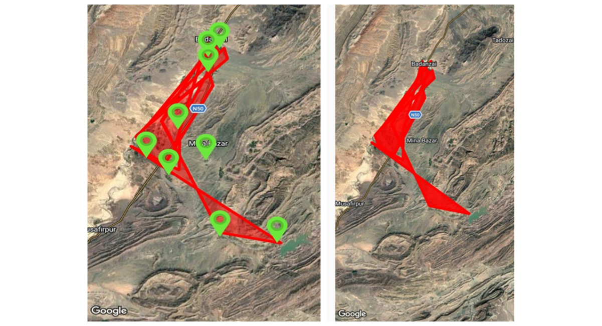
Figure 5: Agricultural Expansion of The Study Area Without Barren
Satellite-Image Interpretation and Land-Cover Mapping
Satellite imagery was used to identify and map major land-cover and land-use classes within the study area. The principal classes included:
- Cultivated agricultural land;
- Fruit orchards;
- Barren/uncultivated land;
- River and water features;
- Agricultural expended areas.
The GPS sampling points were overlaid on the satellite imagery to connect field observations with mapped land-use features.
The existing study specifically reports the use of Google Satellite imagery and open geospatial datasets to identify cultivated land, barren land, transportation networks.
Groundwater Availability Assessment
Groundwater availability was assessed by measuring the depth of water in tube wells/boreholes at the selected sampling locations. Two tube wells were assessed at each sampling point where available. Measurements were recorded during three seasonal periods: winter, spring, and summer/monsoon.
The recorded depth represented the distance from the ground surface to the groundwater level and was recorded in feet. The measurements were compared among sampling locations and seasons to identify spatial and seasonal differences in groundwater availability.
The study recorded groundwater depths ranging approximately from 198.43 to 328.08 feet across the sampling locations. The groundwater observations were used as an indicator of water availability for agricultural irrigation.
Importantly, the study measured water depth in wells/boreholes, not groundwater recharge rates directly. Therefore, the results are interpreted as evidence of groundwater availability and seasonal variation rather than as a quantitative measurement of aquifer recharge.
Irrigation-Source Assessment
The principal irrigation source was recorded at each sampling point through field observation. Irrigation sources were categorized into:
- Groundwater from tube wells/boreholes;
- Solar-powered tube wells;
- Sabakzai Dam/canal irrigation;
- Collective other irrigation sources include diesel and electric pumping systems.
The presence of solar-powered irrigation systems was recorded during field surveys. The spatial distribution of irrigation systems was compared with agricultural expansion to examine whether areas with improved irrigation access were associated with increased cultivation.
Solar-Powered Irrigation Assessment
Solar-powered irrigation was assessed through direct field observation of photovoltaic panels, tube-well installations, pumps, and associated irrigation infrastructure.
At each relevant location, the presence or absence of solar-powered irrigation was recorded. The observations were subsequently compared with the distribution of agricultural fields and orchards.
The study used the presence of solar-powered tube wells as an indicator of the transition from conventional pumping systems toward renewable-energy-based irrigation. The existing field observations indicate widespread adoption of solar irrigation within the agricultural corridor.
Crop and Orchard Diversity Assessment
Crop diversity was assessed through direct field observations during the survey period. Crops were categorized into fruit orchards, vegetables, and seasonal crops. The observed fruit crops included apples, apricots, almonds, figs, and grapes. Vegetables included tomato, onion, and garlic, while seasonal crops included pumpkin, ladyfinger/okra, bottle gourd, cucumber, maize, ridge gourd, carrot, radish, wheat, and barley.
The presence of diverse crops and orchards was used as an indicator of agricultural development and diversification following improved access to irrigation water.
Agricultural Restoration Assessment
Agricultural restoration was evaluated by integrating the major field and spatial indicators. The principal indicators were:
- Increase in cultivated land;
- Conversion of barren land to agricultural land;
- Development of fruit orchards;
- Increase in vegetation cover;
- Improved access to irrigation;
- Availability of groundwater;
- Expansion of solar-powered irrigation.
These indicators were assessed using GPS observations, satellite imagery, GIS-derived areas, groundwater-depth observations, and field photographs.
The spatial evidence was used to characterize the transformation of the landscape rather than to establish an experimental causal relationship between the dam and each individual environmental change.
Data Quality Control
GPS coordinates were checked before their integration into the GIS database. Sampling points were maintained using consistent identification codes from SP-1 to SP-10.
The spatial positions of GPS points were compared with satellite imagery and field observations to minimize location errors. Field observations were also cross-checked with visible landscape features.
The use of GPS coordinates, mobile GIS applications, field photographs, and satellite imagery provided multiple sources of evidence for interpreting agricultural expansion and environmental restoration.
Data Analysis Approach
The study primarily employed descriptive, spatial, and comparative analysis. GPS and GIS data was used to calculate land areas and percentages and to examine spatial relationships among agricultural land, vegetation, groundwater-related infrastructure, irrigation systems, the Zhob River, Sabakzai Dam, and sampling points.
Groundwater-depth observations were compared among locations and seasons. Agricultural and vegetation conditions were interpreted from field observations and satellite imagery.
The combined evidence was then used to assess the extent of agricultural expansion and restoration to characterize the relationship between water availability, irrigation development, vegetation improvement, and land restoration.
Critical analysis and Findings
Field observations indicated that agricultural activities have expanded considerably along the upper bank of the Zhob River following improvements in groundwater availability associated with the Sabakzai Dam. Areas that were previously barren or sparsely vegetated have gradually been converted into productive agricultural land supporting fruit orchards and seasonal vegetable cultivation. The increasing use of solar-powered tube wells has further improved irrigation reliability while reducing operational costs and dependence on diesel fuel.
The findings suggest that groundwater recharge associated with seasonal river flow and the Sabakzai Dam has contributed to improved water availability for agriculture. Farmers reported greater confidence in cultivating high-value crops due to more reliable irrigation throughout the growing season.
Agricultural Land expansion
Table-2 presents the extent of agricultural expansion and figure-6 is the evidence of observed study area located between Sabakzai Dam and the upper bank of the Zhob River. The total study area covers 18,465 hectares, of which 16,235 hectares (87.92%) remain barren or uncultivated. Before 2000, only 50 hectares (0.27%) were under cultivation. Following the development of irrigation infrastructure, increased groundwater availability, and the use of solar-powered tube wells, an additional 2,230 hectares (12.08%) were converted into productive agricultural land. As a result, the total cultivated area increased to 2,280 hectares (12.35%) of the study area. These findings indicate substantial agricultural expansion and ecosystem restoration in the area between Sabakzai Dam and the Zhob River, where previously unused land has been transformed into orchards and cultivated fields. This expansion has improved land productivity and demonstrates the important role of reliable water resources in supporting sustainable agriculture in this semi-arid region.
|
Parameter |
Area(ha) |
percentage of study area (%) |
|
1)Total study area |
18,465 |
100 |
|
2) barren/uncultivated |
16,235 |
87.92% |
|
2)Previously cultivated area (before 2000) |
50 |
0.27% |
|
3) newly cultivated area (After2000) |
2,230 |
12.08% |
|
4) Total cultivated after restoration |
2,280 |
12.35% |
Table 2: Land Use and Cultivation Status of the Study Area
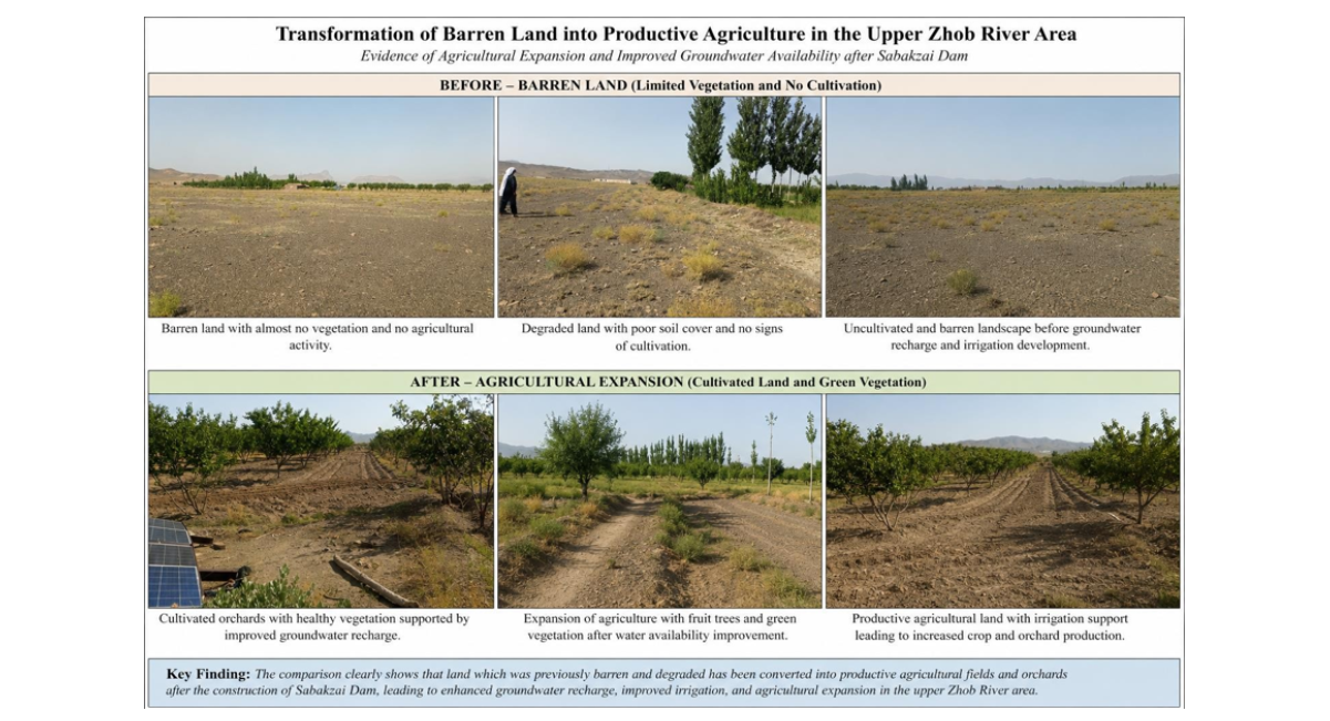
Figure 6: Barren vs Cultivated
Groundwater Recharge and Irrigation sources
Ten sampling points were selected each in every village within the study area, with all other observations on these sampling points, water depth of borehole/tubules were also assessed during all three seasons, and two tubules depth was measured at each sampling point. Table-3 shows that groundwater is the principal source of irrigation in the study area, with groundwater depths ranging from 198.43 to 328.08 feet. Tube wells provide most of the irrigation water, while canal water supplied from Sabakzai Dam serves as a secondary irrigation source. The study found that almost all irrigation is carrying through solar-powered tube wells as photographic evidence in figure-7, whereas some of cultivated land receives irrigation from canals connected to the dam. Field observations further indicate that groundwater recharge is mainly influenced by summer monsoon rainfall (in all three seasons of winter, spring and summer) together with recharge from the Sabakzai Dam and the Zhob River. It was also observed that consecutive two years monsoon droughts totally deplete the underground water for agriculture. These combined water sources have increased water availability for irrigation, contributing to agricultural restoration and the expansion of cultivated land in the study area.
|
Sampling points locations |
GPS Coordinates |
Tubewells (well-1 &2 at each sampling point) water depth (in feet) assessment in seasons |
||||
|
Location |
Latitude |
Longitude |
Winter |
Spring |
Summer (Monsoon) |
|
|
SP-1 |
Sabakzai |
30.95148 |
69.35289 |
280 |
250 |
200 |
|
Dam Rest |
260 |
260 |
180 |
|||
|
House |
||||||
|
SP-2 |
Backside |
30.94194 |
69.33819 |
240 |
260 |
185 |
|
(lakaband) |
250 |
270 |
198 |
|||
|
sabakzai dam |
||||||
|
SP-3 |
Yaqoob Zai |
30.8956 |
69.26642 |
290 |
300 |
270 |
|
farms |
280 |
290 |
250 |
|||
|
SP-4 |
Road fields |
30.95911 |
69.30316 |
190 |
210 |
190 |
|
of Sabakzai |
180 |
220 |
180 |
|||
|
Dam |
||||||
|
SP-5 |
Sawara Pul |
31.03993 |
69.21812 |
270 |
300 |
220 |
|
230 |
320 |
215 |
||||
|
SP-6 |
Mina Bazar |
31.06708 |
69.2526 |
300 |
310 |
270 |
|
320 |
310 |
250 |
||||
|
SP-7 |
Sheikhan |
31.15209 |
69.27302 |
280 |
290 |
240 |
|
285 |
300 |
260 |
||||
|
SP-8 |
Baghawaa(K |
31.17962 |
69.27656 |
290 |
310 |
199 |
|
ili badinzai) |
320 |
330 |
210 |
|||
|
SP-9 |
Kili |
31.18897 |
69.27602 |
340 |
340 |
270 |
|
Baghcha(bad |
300 |
350 |
280 |
|||
|
inzai) |
||||||
|
SP-10 |
Badinzai Zhara |
31.22915 |
69.299 |
290 |
300 |
230 |
|
300 |
310 |
250 |
||||
Table 3: Sampling Point Locations, GPS Coordinates, and Seasonal Tubewell Water Depth Assessment
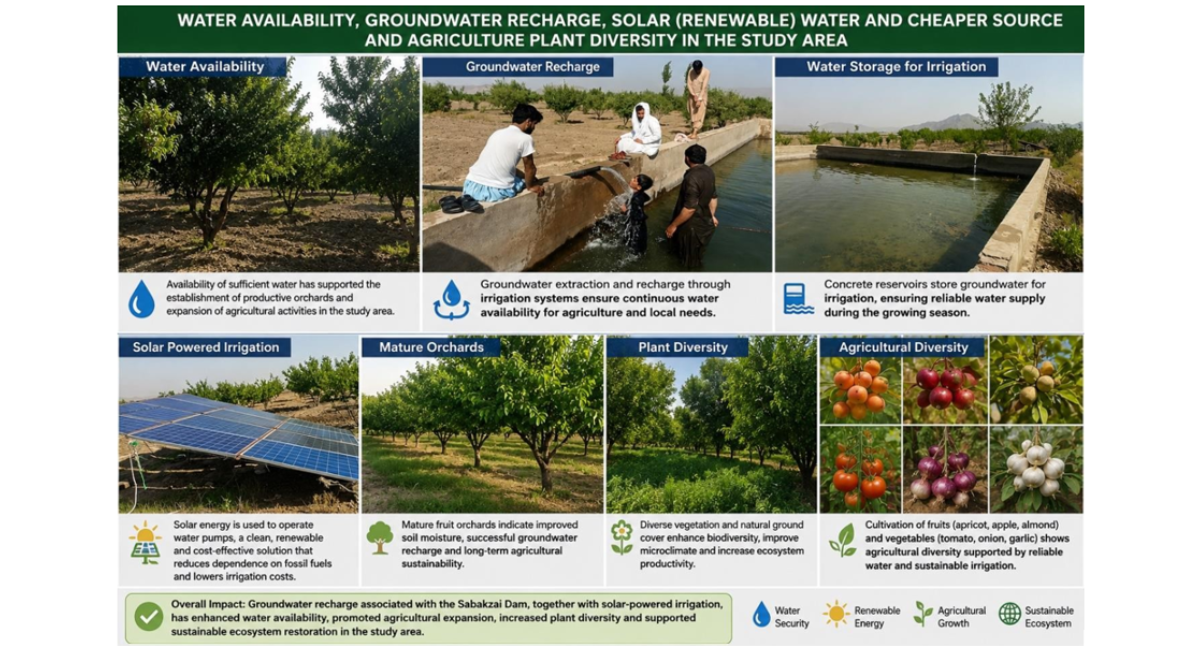
Figure 7: Integrated Water Management, Solar Irrigation, and Agricultural Diversity in the Study Area
Crop Diversity
Table- 4 indicates that agricultural restoration has significantly increased crop diversity in the study area. The restored lands support a wide range of fruit orchards, including apples, apricots, almonds, fig, and grapes, reflecting the suitability of the area for perennial horticulture. Farmers also cultivate vegetables such as tomato, onion, and garlic throughout the year. During the summer season, crops including tomato, pumpkin, ladyfinger (okra), bottle gourd, cucumber, maize, and ridge gourd are commonly grown, whereas winter cultivation mainly consists of garlic, onion, carrot, radish, wheat, and barley. These findings demonstrate that improved irrigation and groundwater availability have enabled year-round cultivation, enhanced crop diversification, and strengthened agricultural productivity in the restored agricultural landscape.
|
CROP CATEGORY |
EXAMPLES |
|
FRUIT ORCHARDS |
Apple, apricot, almond, fig, grapes |
|
VEGETABLES |
Tomato, onion, garlic |
|
SEASONAL CROPS (SUMMER) |
Tomato, pumpkin, ladyfinger, Onion, Bottle gourd, cucumber, maize, ridge Gourd, |
|
WINTER CROPS |
Garlic, onion, carrot, Radish, wheat, barley |
Table 4: Major Crop Categories and Examples of Crops in the Study Area
Cost-benefit analysis
Table -5 shows that although the installation of solar-powered irrigation systems requires a high initial investment, they provide substantial long-term economic benefits through low operating and maintenance costs. The availability of groundwater, reliable irrigation, and proximity to the N-50 highway have improved agricultural restoration, crop productivity, market access, employment opportunities, and farm income. While farmers continue to incur recurring costs for fertilizers, seeds, pesticides, and land preparation, these expenses are outweighed by the increased agricultural production and reduced energy costs. Overall, the cost-benefit analysis indicates that solar-powered irrigation is an economically sustainable approach for agricultural restoration in the study area.
|
Parameter |
Cost/Benefit |
Justification |
|
Solar irrigation system |
High initial investment |
One time installation cost; low operating and maintenance costs over its service life |
|
Energy cost |
Benefit |
No recurring diesel or electricity costs after installation |
|
Ground water availability |
Benefit |
Ground water is available and can be pumped throughout the growing season, depending on aquifer condition |
|
Irrigation reliability |
Benefit |
Regular irrigation support crop growth and reduces dependence on rainfall |
|
Land restoration |
Benefit |
Increased agriculture by cultivating the new land |
|
Market accessibility |
Benefit |
Proximity to the N-50 national highway reduces transportation time and costs |
|
Crop productivity |
Benefit |
Crop production is proportional to water availability |
|
Transportation business |
Benefit |
A local business for transporters |
|
Employment opportunities |
Benefit |
Upgrade opportunities for local people |
|
Farm income |
Benefit |
Increased cultivation & production improve household income |
|
Fertilizers |
Cost |
Rising fertilizer and other organic manure prices increase production cost |
|
Seed prices |
Cost |
Increasing seed prices has a negative impact |
|
Pesticides |
Cost |
Pest management expenses remain a significant recuring cost |
|
Ploughing (land preparation) |
Cost |
Seasonal ploughing adds to production expenses |
|
Maintenance |
Low cost |
Solar panels and pumps require periodic cleaning and occasional maintenance |
|
Overall economic outcome |
Net benefit |
Long-term benefits outweigh the initial investment because of low energy costs and increased agricultural production |
Table 5: Economic Costs, Benefits, and Overall Outcomes of Solar-Powered Irrigation in the Study Area
Overall restoration assessment
Table -6 summarizes the overall outcomes of ecosystem restoration in the study area. Groundwater recharge increased the water table, providing a reliable water source for agriculture and resulting in a high positive impact. Agricultural land expanded from 10 to 410 hectares, representing a very high level of restoration. Orchard development also increased substantially, with a greater diversity and quantity of fruit trees, indicating a high impact on agricultural productivity. The widespread adoption of solar-powered irrigation enabled cultivation of previously uncultivated land and had a very high impact on agricultural expansion. Farmers' livelihoods improved through increased crop production, employment opportunities, and household income. The cost-benefit analysis showed that the long-term economic benefits of restoration outweighed the initial investment, resulting in an overall positive outcome.
Vegetation cover increased significantly along the upper bank of the Zhob River, improving ecosystem health, while land degradation and sheet erosion were reduced through restoration measures. Overall, the assessment demonstrates that the restoration program successfully enhanced environmental conditions, agricultural productivity, and socio-economic well-being, supporting sustainable land management in the study area.
|
Parameter |
Observation |
Impact |
|
Groundwater recharge |
Water table increased |
High |
|
Agricultural expansion |
Calculated & expanded from 50 to 2,230hectares. |
Very high |
|
Orchard development |
High quantity & diversity was observed |
High |
|
Solar-powered irrigation |
Solar tube wells enabled irrigation in previously uncultivated land |
Very high |
|
Farmers’ livelihood |
Production & employment opportunities increased |
High |
|
Cost-benefits analysis |
Almost parameter show benefits |
Positive |
|
Vegetation cover |
Green cover increased along the upper bank of river Zhob |
High |
|
Ecosystem restoration |
Land degradation and erosion reduced succeed to sustainability |
Positive |
Table 6: Environmental, Agricultural, and Socioeconomic Impacts of Water Resource Development in the Study Area
DISCUSSION
The findings of this study demonstrate that the combined influence of Sabakzai Dam, groundwater recharge, and the widespread adoption of solar-powered irrigation systems have significantly contributed to agricultural restoration along the upper bank of the Zhob River in District Zhob. The integration of reliable water resources with renewable energy technologies has transformed previously barren land into productive agricultural landscapes, thereby improving environmental conditions and rural livelihoods.
The most significant finding is the substantial increase in cultivated land. Prior to 2000, only 50 hectares (0.27%) of the study area was under cultivation, whereas an additional 2,230 ha was converted into productive farmland after improvements in groundwater availability and irrigation infrastructure. Consequently, the cultivated area increased to 2,280 ha (12.35%) of the total study area. These findings demonstrate the critical role of water availability in determining agricultural productivity within semi-arid environments. Similar observations have been reported in studies of small reservoirs in Balochistan, where improved irrigation infrastructure significantly enhanced agricultural production and land restoration [7].
Groundwater recharge emerged as one of the primary drivers of ecosystem restoration. Seasonal runoff from the Zhob River together with recharge from Sabakzai Dam contributed to improved groundwater availability, allowing farmers to cultivate land that had previously remained uncultivated because of water scarcity. Groundwater depths ranging from 198.43 to 328.08 ft indicate that productive aquifers remain available throughout much of the study area. Similar relationships between artificial recharge, groundwater sustainability, and agricultural productivity have been documented in arid and semi-arid regions worldwide [9].
Another important finding is the rapid adoption of solar-powered irrigation systems, which now account for approximately 98% of irrigation in the study area. Solar-powered tube wells have substantially reduced farmers' dependence on diesel fuel, resulting in lower operating costs and more reliable irrigation during the growing season. Renewable-energy-based irrigation has been recognized as an effective climate adaptation strategy because it reduces greenhouse gas emissions while improving agricultural productivity [10].
Crop diversity also increased considerably following agricultural restoration. The establishment of orchards containing apples, apricots, almonds, grapes, and figs, together with year-round vegetable cultivation, demonstrates that improved irrigation has enabled more intensive and diversified farming systems. Increased crop diversity contributes to greater resilience against climatic variability and market fluctuations while improving household food security [9].
The findings of the present study indicate that solar-powered irrigation provides a positive long-term economic opportunity for agricultural restoration in the Sabakzai area, as the relatively high initial investment can be offset by lower energy expenditure, more reliable irrigation, increased cultivation of previously underutilized land, and improved agricultural production. This finding is broadly consistent with advanced empirical research: Gupta, using a difference-in-differences approach with 414 farmers in Rajasthan, found that solar pumps reduced diesel and electricity consumption while increasing cropping intensity, fruit and vegetable cultivation, and farmers’ profits [11]. Similarly, a life-cycle economic assessment in Andhra Pradesh found solar irrigation pumps economically feasible because of their comparatively low operating costs over their service life [12]. For Pakistan, Hussain, reported that solar irrigation has strong potential to reduce the high operating costs of conventional irrigation, although financial, technical, and groundwater-management constraints remain important [13].
Importantly, recent evidence demonstrates that the economic benefit of solar irrigation cannot be separated from groundwater sustainability: solar pumping may increase groundwater abstraction where pumping becomes almost cost-free, whereas appropriate incentives and groundwater-management mechanisms can instead promote conservation [14-15]. Therefore, the Sabakzai findings suggest that solar irrigation can strengthen agricultural restoration, farm income, and local economic activity, but its long-term sustainability depends on groundwater monitoring, efficient irrigation, appropriate crop selection, and regular maintenance of solar pumping systems. This interpretation is particularly relevant to Pakistan, where recent research has emphasized the transition from conventional to solar tube-well irrigation while recognizing groundwater sustainability as a critical management issue [16].
Environmental restoration indicators further support the effectiveness of the restoration Programme. Vegetation cover increased markedly, soil moisture improved, and sheet erosion declined because of increased plant cover and improved land management practices. Enhanced vegetation stabilizes soil, improves infiltration, reduces runoff, and contributes to ecosystem resilience under changing climatic conditions [1].
Although the results clearly demonstrate positive environmental and socioeconomic outcomes, sustainable groundwater management remains essential. Increasing groundwater abstraction associated with expanding agriculture could place future pressure on aquifer resources if recharge rates decline because of prolonged drought or climate change. Continued groundwater monitoring, efficient irrigation technologies, and integrated watershed management will therefore be necessary to maintain long-term sustainability [9].
Overall, the findings indicate that the combined effects of groundwater recharge, Sabakzai Dam, and renewable-energy irrigation have created a successful model of agricultural restoration that can potentially be replicated in other semi-arid regions of Balochistan.
CONCLUSION
This study assessed agricultural restoration along the upper bank of the Zhob River in District Zhob using field observations, GPS surveys, GIS analysis, and satellite image interpretation. The results demonstrate that the interaction between Sabakzai Dam, groundwater recharge, and solar-powered irrigation has substantially enhanced agricultural productivity, environmental restoration, and rural socioeconomic development.
Agricultural restoration increased cultivated land from 50 ha (%) before 2000 to 2,280ha (12.35%) after restoration, representing one of the most significant land-use changes within the study area. Previously barren land has been successfully converted into productive orchards and vegetable farms, thereby increasing vegetation cover, improving soil moisture, and reducing land degradation [17-18].
Groundwater recharge from the Zhob River and Sabakzai Dam has significantly improved irrigation reliability. The widespread adoption of solar-powered tube wells has reduced irrigation costs, minimized dependence on fossil fuels, and increased energy efficiency, making agriculture more economically and environmentally sustainable.
The restoration Programme has also generated substantial socioeconomic benefits, including higher farmer incomes, increased employment opportunities, improved market access, enhanced crop diversity, and greater year-round availability of fruits and vegetables. These changes have strengthened local food security and contributed to overall rural development.
Despite these positive outcomes, sustainable groundwater management remains essential for maintaining long-term agricultural productivity [19-21]. Future management strategies should promote efficient water use, groundwater monitoring, and climate-resilient agricultural practices to ensure that continued agricultural expansion does not exceed the natural recharge capacity of local aquifers.
Overall, this study demonstrates that integrating groundwater recharge, surface water storage, renewable energy, and sustainable land management provides an effective approach for restoring degraded agricultural landscapes in semi-arid regions [22-23]. The findings offer a practical framework for policymakers, water managers, and development agencies seeking to promote sustainable agricultural restoration in Balochistan and similar environments.
REFERENCES
- Intergovernmental Panel on Climate (2023). Climate Change 2023: Synthesis Report. IPCC.
- MacAllister DJ, Krishan G, Basharat M, Cuba D, MacDonald AM. A century of groundwater accumulation in Pakistan and northwest India. Nature Geoscience. 2022;15(5):390-6. [Crossref] [Google Scholar]
- Water and Power Development Authority (WAPDA). (2007). Sabakzai Dam Project Brief. Government of Pakistan.
- Government of Balochistan Irrigation Department (2023). Presentation/Brief on irrigation and water conservation projects in Government of Balochistan.
- Pakistan Meteorological (2023). Climate normals of Pakistan (1991–2020) . Government of Pakistan.
- Ali Abbas S & Khan MA (2021). Climate variability and drought characteristics in Balochistan Province, Pakistan. Theoretical and Applied Climatology, 145(3–4), 1185–1201.
- Sultan A, Rehman T. Small dams in Balochistan are the key to uplift agriculture of the area: A case study of Sabakzai Dam in District Zhob. Journal of Xi’an Shiyou University, Natural Science Edition. 2022. [Google Scholar]
- Aslam M, Khan Y, Sadozai KN, Khan H. SOCIOECONOMIC AND AGRICULTURE PRODUCTIVITY IMPACT OF SABAKZAI DAM: A CASE STUDY OF BALOCHISTAN, PAKISTAN. ASSAJ. 2024;2(4):1090-109. [Google Scholar]
- Food and Agriculture Organization of the United (2023). The State of Food and Agriculture 2023: Revealing the true cost of food to transform agrifood systems . FAO.
- International Renewable Energy (2022). Renewable energy for sustainable agriculture . IRENA.
- Gupta E. The impact of solar water pumps on energy-water-food nexus: Evidence from Rajasthan, India. Energy Policy. 2019;129:598-609. [Crossref] [Google Scholar]
- VR R, Jha GK, Sinha JP. Economic feasibility of solar irrigation pump in India: an insight from Andhra Pradesh. Indian Journal of Agricultural Sciences. 2021;91(2):236-9. [Crossref] [Google Scholar]
- Hussain F, Maeng SJ, Cheema MJ, Anjum MN, Afzal A, Azam M, et al. Solar irrigation potential, key issues and challenges in Pakistan. Water. 2023;15(9):1727. [Crossref] [Google Scholar]
- Alam MF, Varshney D, Pavelic P, Sikka A, Krishnan S, Dodiya M. Do Grid-Connected Solar Irrigation Pumps Help Promote Groundwater Sustainability?: Evidence from India. Energy Nexus. 2026:100746. [Crossref] [Google Scholar]
- Shah T, Rajan A, Rai GP, Verma S, Durga N. Solar pumps and South Asia’s energy-groundwater nexus: exploring implications and reimagining its future. Environmental Research Letters. 2018;13(11):115003. [Crossref] [Google Scholar]
- Khan A, Ahmed I, Khair SM. Sustainable Irrigation: A Shift From Conventional to Solar Tube‐Wells. Groundwater. 2025;63(3):326-34. [Crossref] [Google Scholar] [PubMed]
- Ahmad B, Nadeem MU, Liu T, Asif M, Rizvi FF, Kamran A, et al. Climate change impact on groundwater-based livelihood in Soan river basin of Pakistan (South Asia) based on the perception of local farmers. Water. 2023;15(7):1287. [Crossref] [Google Scholar]
- Pörtner HO, Roberts DC, Adams H, Adler C, Aldunce P, Ali E, et al. Climate change 2022: Impacts, adaptation and vulnerability. [Crossref] [Google Scholar]
- Watto MA, Bashir S & Niazi NK (2018). Better management of groundwater needed in Nature. 554(7692), 300.
- Government of (n.d.). About District Zhob. Zhob Division Administration.
- Jensen JR. Introductory digital image processing: a remote sensing perspective. [Crossref] [Google Scholar]
- Lillesand M, Kiefer RW, & Chipman JW. (2022). Remote sensing and image interpretation (8th ed.). Wiley.
- Yin RK. Case study research and applications. Thousand Oaks, CA: sage; 2018. [Crossref] [Google Scholar]

Article Processing Timeline
| Stage 1 |
Initial Quality & Plagiarism Check The manuscript is reviewed for journal scope, basic submission requirements, ethical compliance, and similarity/plagiarism concerns. |
| Stage 2 |
Editorial Assessment & Peer Review Manuscripts that pass the initial screening undergo editorial assessment and independent peer review in accordance with the journal's peer-review policy. |
| Stage 3 |
Revision & Editorial Decision Authors may be requested to revise their manuscript based on reviewer and editor comments. A final editorial decision is made after the required review and revision stages are completed. |
| Stage 4 |
Production & Publication Accepted manuscripts proceed to production, author proofing, final quality checks, and online publication. |
EDITORIAL & PUBLICATION INFORMATION
| English | Publication Language |
| Single-Blind | Peer-Review Model |
| 17% | Acceptance Rate |
| <18% | Similarity Screening Guideline |
| Open Access | Access Model |
All manuscripts undergo editorial assessment and originality screening as part of the journal's evaluation process. The acceptance rate shown is based on journal-level editorial data and may change over time. Similarity reports are assessed editorially and are not interpreted solely on the basis of a numerical similarity score.
Why Publish with us?
Ethics & Policies
Editorial & Management
Useful Links
Journal Highlights
Open Access Journals
Journal Flyer