


Journal of Climate Change and Pollution
ISSN:
3108-2025 (Online)
DOI Prefix (Crossref): 10.67238
 Download PDF
ABSTRACT
Climate change profoundly impacts on human livelihoods and also socioeconomic development, particularly, by increasing floods and drought disasters more and more. These challenges often limit and barrier on community access to clean-safe water and reliable food sources in the community. Thus, community-based adaptation is significant for enhancing local resilience and climate preparedness. This study aims to improve the accessibility and sustainability of water and food security by developing groundwater and public village pond infrastructure for the community. Hence, research team conducted comprehensive desk reviews and site assessments of the relevant literature, stakeholder consultation meetings and local knowledge-sharing were also organized with key district authorities, beneficiaries, and researchers in order to co-design on infrastructures and construction work. Consequently, two groundwater systems were constructed, each equipped with a concrete tower structure, a 2000-liter water tank, and an electric water pump. Additionally, a public village pond with dimensions (60 m x 120 m with an average depth of 2.5 m to 3 m) was created by constructing an earthen embankment across a seasonal stream to optimize water storage. The findings indicate that these infrastructures provided clean-safe water, year-round tap water, eliminating the reliance on contaminated temporary ponds during the wet season. Besides, the rehabilitated pond established is a secondary food source while fostering a strong sense of local ownership and equitable responsibility. Eventually, these outcomes will enhance and promote local livelihoods, alleviate poverty, and support the District Social-Economic Development Plan.
Keywords: Adaptation; Community; Climate Change; Food; Groundwater
INTRODUCTION
Climate change has occurred as one of the most significant and multi-dimensional threats to environment and global sustainable development, to act as a profound risk multiplier across both ecological and human systems. Meaningfully, these anthropogenic climatic shifts are rushing the volatility of the global hydrological cycle, driving a marked increase in both the frequency and severity of hydro-climatic extremes ranging from disastrous, high-rate flooding to extended, multi-year droughts [1]. The socioeconomic consequences of these shifting patterns are circulated unevenly, inflicting the most severe damage on vulnerable rural populations who lack the infrastructural and financial buffers to withstand sudden environmental appearances [2]. Due to the community relies directly on foreseeable weather patterns, the immediate consequence of these climate-induced hazards is a systematic interruption of localized water resource networks and agricultural frameworks, When prolonged droughts reduce aquifer reserves and extreme flood contaminated superficial water tables, the structural foundation of rural survival breaks [3]. This directly conciliations community access to potable drinking water and destabilizes food supply chains, triggering cascading crises of malnutrition, economic displacement, and resource scarcity. Consequently, uncoupling the symbiotic vulnerabilities of water and food insecurity under an increasingly unpredictable climate has transitioned from a localized management issue to a crucial, non-negotiable priority for international researchers and global policymakers alike [4].
Champhone District is located in Savannakhet Province, Lao PDR, most of residents are relies on seasonal surface water leaves communities highly susceptible to climate variability. When surface sources dry up or become polluted and contaminated during extreme weather events, groundwater serves as a vital and resilient buffer [5].
This dependance brings the operational realities of the "Water-Food Security Nexus" into sharp focus. In this framework, therefore, groundwater is not only an alternative resource, but the foundational anchor that directly governs the viability of dry-season irrigation, the stability of localized agricultural yields and the continuous supply of safe domestic water for local community.
Despite its serious importance, securing this resource remains a multifaceted challenge. conventional, top-down engineering interventions frequently fall short of long-term sustainability. Due to these are often designed in isolation from the community, they routinely suffer from institutional abandonment, inadequate local maintenance frameworks, and a fundamental misalignment with the nuanced socio-ecological dynamics and traditional resource-sharing practices inimitable to the target [6]. Therefore, to move beyond decently technical solutions toward models that actively integrate local agency and ecological context is important to preservation the region's climate resilience.
To integrate this gap and address the systematic deficits of traditional development models. Community-Based Adaptation (CBA) has progressively been known as a dynamic paradigm shift in the address of climate resilience [7]. To move away from protective, technocratic approaches, CBA explicitly positions local communities as the primary agents at the center of coordinating, planning, designing, and executing localized adaptation strategies [8]. This bottom-up method descends its efficacy from its capacity to systematically leverage indigenous and contextual knowledge systems, fostering a deep-seated sense of institutional ownership among resource users, and establish transparent, impartial frameworks for resource distribution, additionally, by grounding technical initiatives within the community's existing social fabric, CBA ensures that physical infrastructure interventions are not only culturally corresponding but also operationally and financially sustainable over the long term, independent of external oversight [9-10]. Despite these clear conceptual merits, a significant gap persists between theoretical advocacy and field-level evidence. Empirical studies that reveal the tangible, quantifiable integration of CBA within the highly complex groundwater-food security nexus particularly through the co-design and participatory management of small-scale infrastructure remain starkly limited across the developing rural landscape [11,12]. This scarcity of pragmatic validation emphasizes a critical research discrepancy, leaving policymakers with few proved models for scaling community-led groundwater governance in highly vulnerable area.
To discourse these intersecting challenges, this study aims to improve both the operational accessibility and the long-term sustainable water and food security by developing and accessing community-led infrastructure models [13]. Definitely, this research evaluates and documents the iterative co-design, implementation, and socio-technical performance of managed groundwater extraction systems alongside multi-purpose public village pond infrastructure [14]. Rather than treating engineering and community engagement as separate phases, this study uses a deeply integrated, participatory methods that seamlessly links extensive desk reviews and rigorous baseline site assessments with multi-stakeholder consultations and co-design workshops [15,16]. Through this collaborative approach, the research empirically determines how institutional local ownership, community agency, and proactive climate readiness can be simultaneously co-generated and sustained [17]. Eventually, the insights and structural frameworks added from this field intervention offer a highly scalable, socio-ecologically grounded model for stabilizing rural livelihoods, improving entrenched rural poverty, and directly reinforcing decentralized, district-level socio-economic development plans (SEDPs) in contradiction of the backdrop of intensifying and unpredictable climate change [18,19].
MATERIALS AND METHODS
Study Area Context
The targeted community is situated in Champhone District, Savannakhet Province, Lao PDR, it is about 14 kilometers southeast of the district administrative center, the village is organized into two distinct residential clusters, locally namely as Khoum: NonKhay and Pakouay. This cluster plays a critical role in shaping local resource distribution, spatial accessibility to water bodies, and decentralized community decision-making frameworks.
Demographically, the village establishes a compact highly dense rural settlement, comprising a total of 154 households. There are 749 residents, included women of 364 persons (approximately 48.6% of the total population). Hence, the balanced gender distribution underlines the importance of integrating gender-responsive methods into local climate adaptation strategies. In particular, as women are frequently the key person of domestic water security and household health in rural community.
Socio-economically, the community shows a high degree of vulnerability and economic insecurity. There are total of 43 families representing approximately 28% of the village's total households are officially classified as living below the poverty line according to national multidimensional poverty index. This economic precarity is additional reflected in the community's baseline financial system of measurement, which the average annual income is estimated at 2,000,000 LAK per capita.
Domestic water insecurity constitutes a severe and prevalent structural barrier within the target community. Currently, only 43 households possess the financial capacity to rely on commercially purveyed 20-liter bottled water as their primary source of potable drinking water. The overwhelming majority of the population is forced to depend on untreated, highly vulnerable environmental sources, including seasonal local streams, exposed natural springs, and unconfined shallow aquifers.
Consequently, the net volumetric supply of safe water allocated for essential drinking, food preparation, and basic sanitation tasks is critically deficient [20].
This reliance on insecure surface and groundwater water bodies exposes the community to acute seasonal variations in water quality, compounding local public health risks through potential bacterial and sediment contamination.
A baseline site assessment was conducted prior to the intervention revealed on18 groundwater boreholes installed across the two residential clusters, 83.3% has fallen into complete disorder, only three boreholes fully work.
As a direct consequence of this severe infrastructure shortage, the average domestic water consumption within the community has contracted to a marginal 10 to 15 liters per capita per day.
The current consumption rate falls drastically short of the 50 to 100 liters per capita per day benchmark mandated by the World Health Organization (WHO) necessary to assurance baseline personal hygiene, health protection, and domestic security. This severe volumetric deficit not only elevates the burden of water-related diseases but also suspiciously increases the time and physical labor expended by community members particularly women and youth in sourcing water from distant and alternative supplies.
Rice productivity within the targeted village is constrained, with annual crop yields predominantly rainfed lowland rice stagnating at a critically low baseline averaging between 1.1 and 2.0 tons per hectare. This yield falls intensely below national averages.
The occurrence of salt formations and coupled with inconsistent water tables, drives soil salinity. This salinity uses severe impact on crops, inhibiting root water uptake and inducing toxic ion accumulations that dramatically reduces survival [21,22].
Accordingly, the community is trapped in a chronic cycle of food insecurity and acute seasonal shortages. Because local aggregate rice production routinely fails to satisfy basic household subsistence requirements, the community faces a structural "rice gap" a period of several months each year where domestic grain reserves are entirely exhausted [23,24].
During these lean months, families are forced to pivot toward negative coping strategies, including the liquidation of modest livestock assets, high-interest micro-loans, or cutting back on daily nutritional intake. This persistent caloric and financial strain transforms food from a basic stability metric into a continuous daily crisis.
This systemic agricultural deficit does more than undermine immediate nutritional health; it severely erodes the foundational pillars of community-based climate change adaptation and structurally caps local resilience [25].
To discourse these deeply interconnected hydrological, agronomic, and socioeconomic challenges, this study a comprehensive framework designed to safe equitable and highly sustainable access to vibrant sub-surface water resources. Rather than acting as a temporary relief measure, the planned development of managed groundwater infrastructure functions as a transformative intervention to improve localized climate readiness, mitigate seasonal water scarcity, and support the long-term food security and climate-resilience of rural livelihoods [26]. By steadying the volumetric availability of water for both domestic consumption and off-season agricultural production, the study seeks to break the structural cycle of poverty and resource reduction that currently caps the community's adaptive capacity.
Beyond the immediate structural and engineering interventions within the targeted site, the initiative is built upon a robust, multi-tiered knowledge exchange model designed to maximize regional impact. The project actively facilitates structured peer-to-peer knowledge sharing and cross-learning exchanges regarding localized governance, equitable water allocation, and infrastructure maintenance best practices among adjacent communities experiencing similar hydro-climatic vulnerabilities, Moreover, to ensure the sustainability of the project's interventions and to contribute to the broader scientific and policy discourse, the research team is committed to a transparent and comprehensive dissemination strategy. The empirical data, technical designs, socio-technical outcomes, and community-led governance frameworks generated throughout this intervention will be systematically shared with public stakeholders, regional development agencies, and national policy architects [27,28].
This intentional data-sharing pipeline transforms a localized field intervention into a scalable blueprint. Providing open-access methodologies and verified field insights directly empowers sub-national and national authorities to integrate community-based groundwater management paradigms into decentralized Socio-Economic Development Plans (SEDPs) across Lao PDR
The paradigm of Community-Based Climate Change Adaptation for Sustainable Water and Food Security (CBC2ASWFS) serves as both the foundational conceptual architecture and the practical operational framework driving this research [29]. Rather than treating climate resilience as an abstract policy objective, this integrated model functions as a systematic, field-tested methodology designed to directly secure, optimize, and sustain community-level water resource access and food production systems [30].
The systemic interaction, structural components, and operational pathways of this community-led adaptation model are schematically illustrated below in Figure 1, mapping out how localized governance transforms climate vulnerability into resource stability.
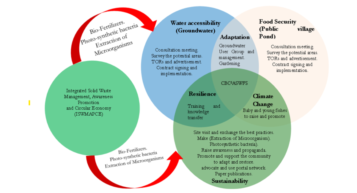
Figure 1: Water and Food Security Nexus Framework Diagram
Data collection
Stakeholder Engagement and Qualitative Data Collection
To accurately recognize an immediate priority of the local population concerning water and food security, the research team, collaboration with district relevant authorities and leadership from the NonKhay cluster (Khoum), which conducted a several intensive community consultation meetings and public hearings [31]. To supplement these consultations and gain more deeper understanding of current socioeconomic conditions and future livelihood needs, therefore, qualitative data were collected employing Key Informant Interviews (KIIs) and Focus Group Discussions (FGDs) [32,33]. KIIs were purposively directed to key community leaders, including the village head, representatives from the Women’s Union, Youth Union, and the leader of the Pakouay cluster. Concurrently, FGDs were facilitated with broader community members to capture diverse local perspectives and co-design sustainable livelihood interventions [34,35].
Site Selection and Infrastructure Siting
During community consultation meetings and public hearings, stakeholders focused primarily on two critical spatial decisions: 1) identifying optimal locations for groundwater extraction, and (2) determining the site for the public village pond [36]. Through this participatory approach, there are two available borehole sites which were selected to secure a groundwater supply. The first borehole is located adjacent to the village community hall, while the second is situated near the central residential hub of the village.
Field Validation and Borehole Siting
Consequently, the research team, district authorities, and community representatives conducted field investigations to validate and finalize the two borehole locations. The selection criteria prioritized sites capable of yielding a sufficient and stable groundwater supply throughout both the wet and dry seasons, while ensuring acceptable water quality parameters (specifically avoiding high salinity zones). Geographically, the study area is considered by severe seasonal drought, primarily driven by an important deficit in annual cumulative rainfall, as illustrated in Figure 2.
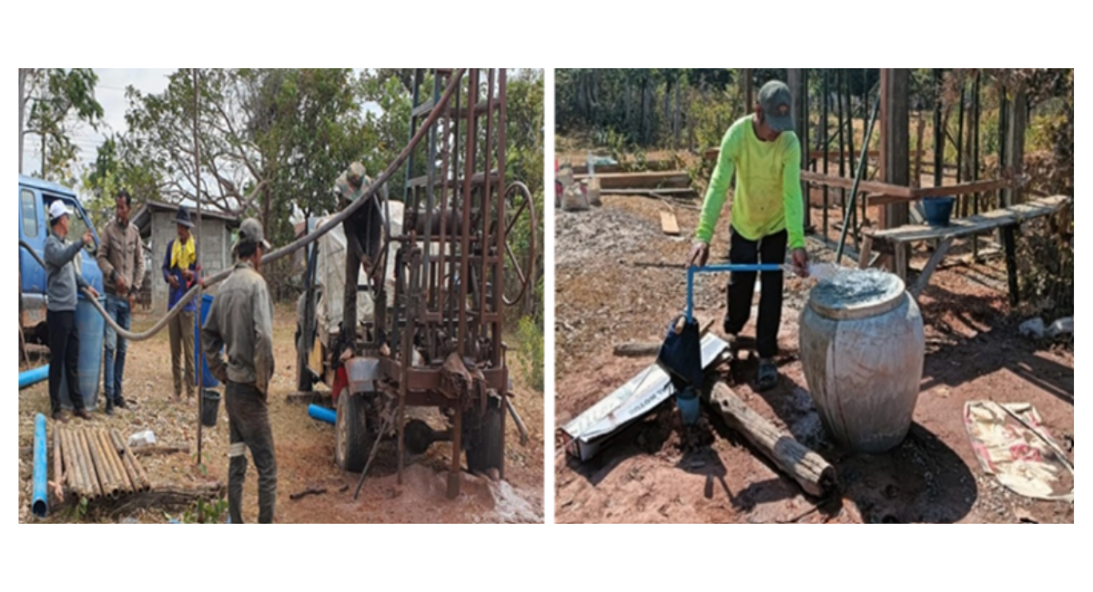
Figure 2: Groundwater Drilling and Water Quantity Test
Site Selection for Public Pond Infrastructure
During the preliminary investigation, there are two potential locations that were generously offered by local landowners to construct a public village pond for instance: a lowland paddy field and an active vegetable gardening area. Research team together with district authority and local community conducted intensive survey that follow a rigorous site survey and environmental investigation, finally, a paddy field was selected as the optimal site [37]. This selection based on advantageous and suitable topographical and hydrological conditions that maximized the sustainable detention and retention of seasonal rainfall runoff [38]. Besides, choosing a paddy field minimized the need for extensive land clearance, thereby mitigating the negative impacts on the surrounding ecosystem compared to the vegetable gardening site [39] as illustrated in Figure 3.
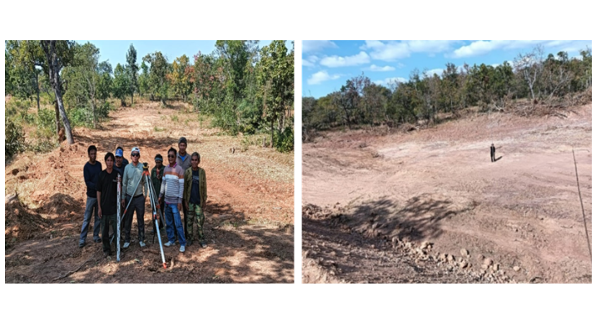
Figure 3: Public pond Infrastructure and Site Preparation
RESULTS AND DISCUSSION
Groundwater Infrastructure Design and Construction
The groundwater supply system was designed on two primary engineering components: (1). borehole drilling, which includes: pumping tests and the installation of a submersible electric pump system, and (2). the construction of an elevated water tower to support the storage tank infrastructure. To ensure long-term hydrologic reliability, drilling operations were performed during the dry season employing a mechanical drilling rig [40]. Siting and drilling during the dry season verified that the aquifer's yield would remain sufficient and sustainable for the targeted water user group during peak scarcity periods. The mechanical drilling process and equipment configuration and details are indicated in Table1.
Groundwater Infrastructure Design and Construction
The groundwater supply system was designed on two primary engineering components: (1). borehole drilling, which includes: pumping tests and the installation of a submersible electric pump system, and (2). the construction of an elevated water tower to support the storage tank infrastructure. To ensure long-term hydrologic reliability, drilling operations were performed during the dry season employing a mechanical drilling rig [40]. Siting and drilling during the dry season verified that the aquifer's yield would remain sufficient and sustainable for the targeted water user group during peak scarcity periods. The mechanical drilling process and equipment configuration and details are indicated in Table1.
|
No |
Parameters |
Baseline conditions |
Major challenges |
Implemented interventions |
|
1 |
Water availability and infrastructure |
Seasonal water scarcity, reliance on rainfed agriculture |
Severe drought during dry season, lack of storage |
Electric-powered groundwater and system Installation |
|
2 |
Agriculture and food security |
Single-crop farming (paddy rice only) |
Low yield, failure crops during dry season |
dry-season vegetable cultivation and an introduction |
|
3 |
Community capacity and governance regium |
Informal water governance |
limitation of technical skills and water scarcity, lack of maintenance funds |
Establishment of water user groups (WUGs) and training, community development fund |
|
4 |
Livelihood and economic Development |
Average household income: 2,000,000 LAK per capita per year |
High vulnerability to climate change, seasonal migration |
Food security (more than 2,500 baby fish released) and water access support for high-demand dry-season crops |
Table 1: Parameters, Baseline Conditions, Major Challenges, Implemented Interventions, and Key Outcomes Summary
Hydraulic Characteristics and Structural Specifications
Drilling machine operate positively, since the static groundwater table was found between a depth of 9.0 m to 10.0 m, with the boreholes reach total achievement depth of almost 35.0 m. Constant-rate pumping tests were completed to assess aquifer productivity, yielding a flow rate of 300 L/h (equivalent to 0.000083 m3/s), if drilling more than 35.0 m that could be reached to salinity water. The associated civil infrastructure comprises of a reinforced concrete water tower with a structural height of 3.5 m, considered to support the primary-storage tank. To ease water extraction and distribution, a submersible electric water pump, corresponding piping systems, and electrical controls were combined into the design of the system. This configuration effectively lifts groundwater from the aquifer to the elevated storage unit, as showed in Figure 4 and detailed are indicated in Table 2.
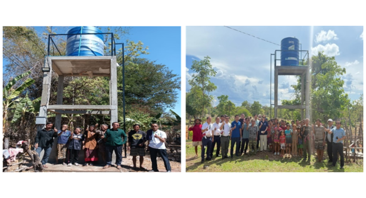
Figure 4: Groundwater Completed Construction System
Public Pond Design and Construction
Public village pond was constructed within an existing agricultural area that was previously dedicated solely to wet-season cultivation. A detailed topographic and cross-sectional survey was conducted to map the natural valley terrain and seasonal stream watercourses [41]. Employing this baseline spatial data, a heavy machinery cut-and-fill was executed: earth was excavated from the natural depression of the valley to maximize the reservoir storage capacity, and the excavated soil was simultaneously used to construct a stable peripheral embankment. By aligning the layout with the natural valley topography, the total volume of the necessary earthworks was significantly reduced [42].
Hence, to mitigate post-construction soil erosion and reservoir sedimentation, the surrounding natural forest was strictly protected [43]. Bamboo trees were planted along the embankment slopes to protect and provide biological soil stabilization while serving as a secondary food resource for the local community. Following excavation, the reservoir bed was treated with quicklime (calcium oxide, CaO) for disinfection and pH adjustment in the pond. Eventually, organic fertilizer in the form of livestock manures were distributed across the pond to react with phytoplankton and algal blooms, thereby establishing a natural nutrient-rich food web for aquaculture development [44].
Reservoir Geometry and Volumetric Capacity
Public pond design and features a surface area footprint of about 60 m by 120 m with an average operational depth ranging from 2.5 m to 3.0 m. Based on the local terrain and catchment topography, the reservoir was designed to impound an estimated volumetric capacity of 18,000 m3 to 21,600 m3, as depicted in Figure 5. This capacity ensures that the optimal retention and storage of direct surface runoff and rainwater during the impending wet season [45].
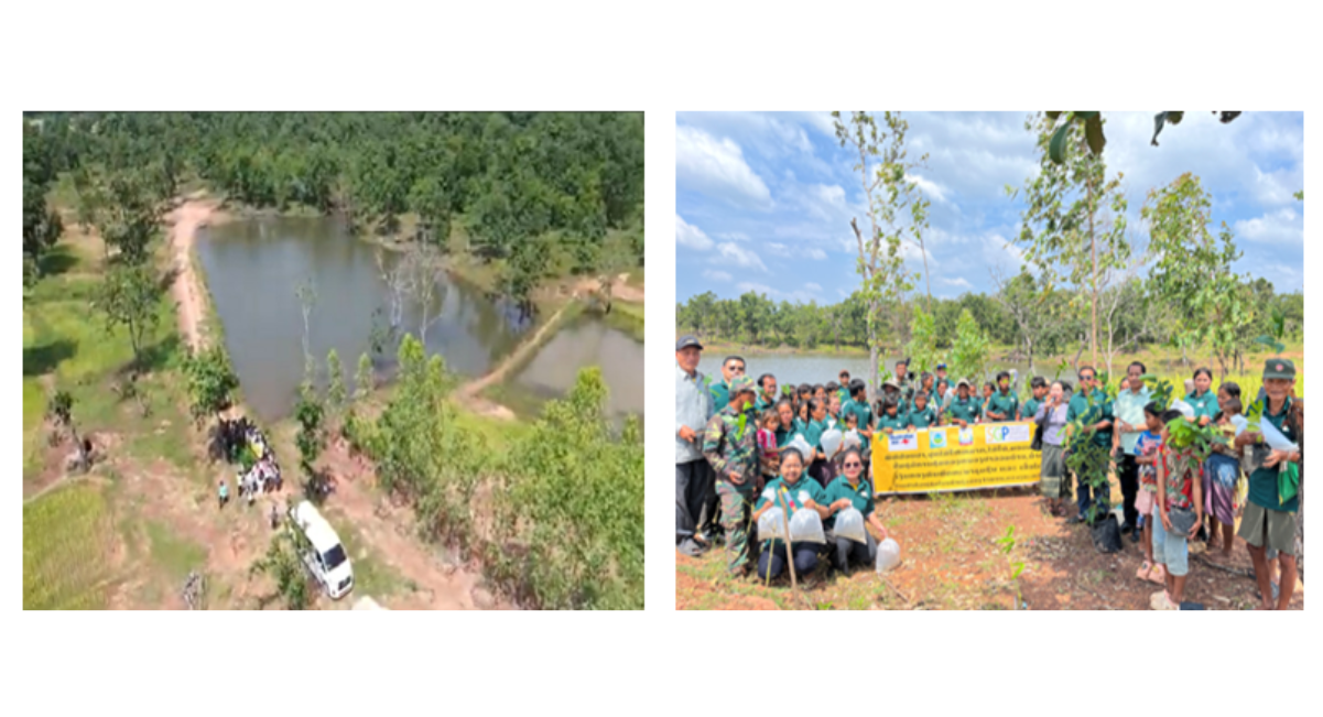
Figure 5: Public Village Pond Completed Construction and Fish Released
|
No |
System |
Technical parameter |
Specification |
Expected benefits |
|
1 |
Groundwater System |
Unit |
2 |
Location:1.Village community hall and 2.Near the central residential hub |
|
Static water level(SWL) |
9-10 m |
The baseline unconfined/semi-confined aquifer level |
||
|
Well depth |
35 m |
Reaches stable aquifer layer, adequate screen length, submergence, and allowance for seasonal drawdown |
||
|
Flow rate |
0.3 m³/hour |
Ensures adequate supply for domestic & agro-use |
||
|
Power source |
24 kV electric grid system |
Stable power and protect pumps from low-voltage damage |
||
|
Distribution network |
500 m PVC pipeline system |
Direct access to agricultural plots for 50 households |
||
|
Water tank |
2000 L |
Store water and distribute to households |
||
|
Pumping system |
500 watts |
Submersible electric water pump |
||
|
Tower concrete structure |
3 m |
Elevate and gravity flow from water storage |
||
|
2 |
Public Pond Infrastructure |
Storage volume(capacity) |
21,600 m³ |
Provides supplementary surface water during drought |
|
Dimensions |
60 m x 20 m x 3 m |
Optimized footprint and storage capacity |
||
|
Slope/Lining Material |
Minimizes seepage losses (< 2.5 mm/day) |
Compacted clay lining |
||
|
Target area and beneficiaries |
1820 m2,154 Households |
Enhances local climate resilience and food security |
||
|
Bio-soil erossion engineering protection |
300 bamboo and 300 fruit trees |
Planted around the pond and green space for future |
Table 2: Technical Specifications and Expected Benefits of Implemented Systems
CONCLUSION
In conclusion, community-based climate change adaptation (CBA) represents a significant and indispensable paradigm for securing and sustaining long-term water and food security within climate-vulnerable rural area. A central pillar of this study’ success was the operationalization of socially inclusive participation. This mechanism served as a transformative platform that effectively integrate local communities, direct beneficiaries, stakeholders, and local authorities. By doing so, it eased the co-creation of knowledge, unburied localized insights, and fostered a transparent framework for sharing both developmental opportunities and long-term resource management responsibilities.
The research found obviously that securing equitable accessibility to water and food resources as a direct act and implementation for holistic community development and climate resilience. Definitely, this intervention proved concrete structural improvements: through groundwater infrastructure, villagers magnificently transitioned to a reliable system of safe, year-round tap water. This structural change successfully eradicated their hazardous reliance on contamination, unprotected temporary ponds during the wet season, thus, mitigating waterborne health risks.
The rehabilitation of the public pond has yielded important co-benefits, functioning as a resilient secondary source of food security and localized aquaculture. Beyond physical infrastructure, the participatory approach has successfully institutionalized a profound sense of local ownership. This psychological and operational buy-in ensures that both the tangible benefits and the administrative responsibilities of the groundwater systems and public ponds are equitably distributed and maintained across the community. Consequently, these integrated outcomes do not only elevate local livelihoods and alleviate deep-seated rural poverty, but they also serve as a scalable, practical indicator that directly supports and strengthens the decentralized District Socio-Economic Development Plan against the backdrop of intensifying climate uncertainties.
ACKNOWLEDGEMENT
The authors would like to acknowledge the Global Environment Facility (GEF), Small Grants Programme, UNDP, The Department of Foreign Affairs and Trade (DFAT) for financial support, District office of Agriculture and Environment (DAE) to fully assist and implement during project implementation, Department of Environmental Engineering, Faculty of Engineering, National University of Laos, and all team members to share experiences and build this up together.
REFERENCES
- Siharath P, Nitivattananon V, Shrestha RP, Vilaychaleun S, Sonemanivong C. The Climate-Wetland-Policy Nexus: Advancing Community-Based Adaptation through Participatory Co-Knowledge Design at Sui Lake, Lao PDR. Current Problems in Research. 2026;2(1):74-89. [Crossref] [Google Scholar]
- Ahmed Z, Guha GS, Shew AM, Alam GM. Climate change risk perceptions and agricultural adaptation strategies in vulnerable riverine char islands of Bangladesh. Land use policy. 2021;103:105295. [Crossref] [Google Scholar]
- ROSMAN FR, SYED AZIZ SS, YUNUS SM. Harmony in Biodiversity: Spearheading the Global Biodiversity Agenda through National Policy on Biological Diversity (NPBD) 2022-2030. Malayan Nature Journal. 2024;76(1):113. [Crossref] [Google Scholar]
- Dieter N, Gerardo LV and Luise R. Community-based Adaptation (CbA), Ecosystem-based Adaptation (EbA) and the Landscape Approach (LA) - Characteristics and Commonalities 2016.
- Vilaychaleun S, Thammathevo K, Phonhalath K, Kannitha S, Sonemanivong C, Keokhamphui K, et al. Community based adaptation to climate change and social economic in Xe Champhone Wetland, Champhone District, Savannakhet Province. Jurnal Ilmiah Multidisiplin Indonesia (JIM-ID). 2024;3(02):67-81. [Crossref] [Google Scholar]
- Mahajan S, Hausladen CI, Sánchez-Vaquerizo JA, Korecki M, Helbing D. Participatory resilience: Surviving, recovering and improving together. Sustainable Cities and Society. 2022;83:103942. [Crossref] [Google Scholar]
- Williams C, Pettman T, Goodwin-Smith I, Tefera Y, Hanifie S, Baldock K. Experiences of research-policy engagement in policy-making processes. Public Health Research and Practice. 2024;34(1):e33232308. [Crossref] [Google Scholar] [PubMed]
- Regmi BR, Star C, Leal Filho W. Effectiveness of the local adaptation plan of action to support climate change adaptation in Nepal. Mitigation and adaptation strategies for global change. 2016;21(3):461-78. [Crossref] [Google Scholar]
- Oliver K, Hopkins A, Boaz A, Guillot-Wright S, Cairney P. What works to promote research-policy engagement?. Evidence & Policy. 2022;18(4):691-713. [Crossref] [Google Scholar]
- Donatti CI, Harvey CA, Hole D, Panfil SN, Schurman H. Indicators to measure the climate change adaptation outcomes of ecosystem-based adaptation. Climatic change. 2020;158(3):413-33. [Crossref] [Google Scholar]
- Eweje G, Sajjad A, Nath SD, Kobayashi K. Multi-stakeholder partnerships: A catalyst to achieve sustainable development goals. Marketing Intelligence & Planning. 2021;39(2):186-212. [Crossref] [Google Scholar]
- Carrard N, Foster T, Willetts J. Groundwater as a source of drinking water in southeast Asia and the Pacific: A multi-country review of current reliance and resource concerns. Water. 2019;11(8):1605. [Crossref] [Google Scholar]
- Keskinen M, Sojamo S, Varis O. Enhancing security, sustainability and resilience in energy, food and water. Sustainability. 2019;11(24):7244. [Crossref] [Google Scholar]
- Logeshwaran E, Jaiswal A, Vaibhav CS, Thangavelu S, Satish A. Empowering Communities for Resilient Water Solutions: A Case Study of Rural India. International Conference on Advances in Materials, Modeling, and Analysis for Sustainable and Resilient Infrastructure 2025(pp. 27-39). Singapore: Springer Nature Singapore. [Crossref] [Google Scholar]
- Yustiarini D, Soemardi BW, Pribadi KS. Integrating multi-stakeholder governance, engineering approaches, and bibliometric literature review insights for sustainable regional road maintenance: Contribution to sustainable development goals (SDGs) 9, 11, and 16. Indonesian Journal of Science and Technology. 2025;10(2):367-98. [Crossref] [Google Scholar]
- Sarmiento Barletti JP, Larson AM, Heise Vigil N. Understanding difference to build bridges among stakeholders: Perceptions of participation in four multi-stakeholder forums in the Peruvian Amazon. The Journal of Development Studies. 2022;58(1):19-37. [Crossref] [Google Scholar]
- Omukuti J. Challenging the obsession with local level institutions in country ownership of climate change adaptation. Land use policy. 2020;94:104525. [Crossref] [Google Scholar]
- Bera M, Nag PK. Integrated natural resource management and sustainable livelihoods: A review of ecosystem-based approaches for sustainability and community resilience. Agricultural & Rural Studies. 2025;3(3):23. [Crossref] [Google Scholar]
- Ain QU, Yousaf T, Tahir MA. Decentralization policies and sustainable rural development: A path to eradicating poverty (SDG 1) and hunger (SDG 2). Sustainable Development. 2025;33(1):700-16. [Crossref] [Google Scholar]
- World Health Organization. Progress on household drinking water, sanitation and hygiene 2000-2022: Special focus on gender. World Health Organization; 2024. [Google Scholar]
- Singh A. Soil salinity: A global threat to sustainable development. Soil Use and Management. 2022;38(1):39-67. [Crossref] [Google Scholar]
- Mishra AK, Das R, George Kerry R, Biswal B, Sinha T, Sharma S, et al. Promising management strategies to improve crop sustainability and to amend soil salinity. Frontiers in Environmental Science. 2023;10:962581. [Crossref] [Google Scholar]
- Yusriadi Y, Cahaya A. Food security systems in rural communities: A qualitative study. Frontiers in Sustainable Food Systems. 2022;6:987853. [Crossref] [Google Scholar]
- Ahmad MM, Yaseen M, Saqib SE. Climate change impacts of drought on the livelihood of dryland smallholders: Implications of adaptation challenges. International Journal of Disaster Risk Reduction. 2022;80:103210. [Crossref] [Google Scholar]
- Delina LL, Shi L, Gaviola J, Cagoco‐Guiam R. Balancing Immediate Relief and Resilience: Centring Local Voices for Disaster Aid and Capacity Building in Climate‐Conflict Vulnerable Communities. Sustainable Development. 2025;33(3):4589-603. [Crossref] [Google Scholar]
- Khalid I, Ahmad T. Climate change vulnerabilities in South Asia: Prospects of water and food security. Journal of Development and Social Sciences. 2021;2(3):451-63. [Crossref] [Google Scholar]
- Rahman TU, Faraz A, Nawaz T, Saud S, Fahad S, Harrison MT. Towards sustainable solutions: Climate change and food security in a globalized world. Food and Energy Security. 2025;14(5):e70126. [Crossref] [Google Scholar]
- Alao JO, Eze SU, Onyenweife GI, Ibe AA, Otorkpa OJ, Ayejoto DA, et al. Enhancing water security through integrated storage mechanisms and rainwater harvesting for sustainable development. Discover Sustainability. 2025;6(1):941. [Crossref] [Google Scholar]
- Wright H, Vermeulen S, Laganda G, Olupot M, Ampaire E, Jat ML. Farmers, food and climate change: ensuring community-based adaptation is mainstreamed into agricultural programmes. Climate and development. 2014;6(4):318-28. [Crossref] [Google Scholar]
- Doustmohammadian A, Mohammadi-Nasrabadi F, Keshavarz-Mohammadi N, Hajjar M, Alibeyk S, Hajigholam-Saryazdi M. Community-based participatory interventions to improve food security: A systematic review. Frontiers in nutrition. 2022;9:1028394. [Crossref] [Google Scholar] [PubMed]
- van Ginkel M, Biradar C. Drought early warning in agri-food systems. Climate. 2021;9(9):134. [Crossref] [Google Scholar]
- Lokot M. Whose voices? Whose knowledge? A feminist analysis of the value of key informant interviews. International Journal of Qualitative Methods. 2021;20:1609406920948775. [Crossref] [Google Scholar]
- Mazigo HD, Samson A, Lambert VJ, Kosia AL, Ngoma DD, Murphy R, Matungwa DJ. “We know about schistosomiasis but we know nothing about FGS”: A qualitative assessment of knowledge gaps about female genital schistosomiasis among communities living in Schistosoma haematobium endemic districts of Zanzibar and Northwestern Tanzania. PLoS neglected tropical diseases. 2021;15(9):e0009789. [Crossref] [Google Scholar] [PubMed]
- Barati MK, Bankaru-Swamy S. A living lab approach to co-designing climate adaptation strategies. Buildings and Cities. 2026;7(1):39-57. [Crossref] [Google Scholar]
- Baudouin‐van Os AC, Pushpalatha R, Sheela S, Mohan R, Vinodini Ramesh M. Co‐Design to Capacity: An Instructional Design Approach for Indigenous Women Empowerment and Sustainable Technology Adoption. Sustainable Development. 2026. [Crossref] [Google Scholar]
- Sneha S, Bhavana P, Gopidas N, Koushik Ram M, Mahesh S, Rohit GV, et al. Empowering Rural Communities: A Collaborative Design Approach for Livelihood Diversification. International Conference on Information and Communication Technology for Intelligent Systems 2025 (pp. 171-181). Singapore: Springer Nature Singapore. [Crossref] [Google Scholar]
- Man J, Chen Y, Fan H, Chen Q, Yao Y. Optimizing soil sampling with information entropy at heavy-metal sites. Acs Es&T Engineering. 2023;3(9):1350-8. [Crossref] [Google Scholar]
- Noori AR, Singh SK. Rainfall assessment and water harvesting potential in an urban area for artificial groundwater recharge with land use and land cover approach. Water Resources Management. 2023;37(13):5215-34. [Crossref] [Google Scholar]
- Yan B, Deng T, Shi L. Towards sustainable productivity of greenhouse vegetable soils: limiting factors and mitigation strategies. Plants. 2024;13(20):2885. [Crossref] [Google Scholar] [PubMed]
- Akbari A. Sustainable approaches to water management and water quality in hydraulic fracturing for unconventional oil and gas development in the united states: A critical review and compilatio The Canadian Journal of Chemical Engineering. 2025;103(9):4220-49. [Crossref] [Google Scholar]
- Ayisi F, Sedou N, Dieunang SK, Yaya F, Tchago EF, Ndellejong CE, et al . A cross-sectional study of Simulium damnosum sl breeding sites and species distribution in sudan savanna, mixed savanna-forest and rainforest regions in Cameroon. [Crossref] [Google Scholar] [PubMed]
- Cook J, Petts RC. Rural Road Engineering in Developing Countries. CRC Press; 2023. [Crossref] [Google Scholar]
- Gallego-Ramírez C, Velásquez L, Chica E, Rubio-Clemente A. Identification and Analysis of the Potential Environmental Impacts Across Installation, Operation, Maintenance, and Dismantling of a Gravitational Water Vortex Turbine. Sustainability. 2026;18(6):2850. [Crossref] [Google Scholar]
- Ogello E, Muthoka M, Outa N. Exploring regenerative aquaculture initiatives for climate-resilient food production: Harnessing synergies between technology and Agroecology. Aquaculture Journal. 2024;4(4):324-44. [Crossref] [Google Scholar]
- Roberts MT, Geris J, Hallett PD, Wilkinson ME. Mitigating floods and attenuating surface runoff with temporary storage areas in headwaters. Wiley Interdisciplinary Reviews: Water. 2023;10(3):e1634. [Crossref] [Google Scholar]

Article Processing Timeline
| 2-5 Days | Initial Quality & Plagiarism Check |
| 25-35 Days |
Peer Review Feedback |
| 45-60 Days | Total article processing time |
EDITORIAL & PUBLICATION INFORMATION
| English | Publication Language |
| Single-Blind | Peer-Review Model |
| 17% | Acceptance Rate |
| <18% | Similarity Screening Guideline |
| Open Access | Access Model |
All manuscripts undergo editorial assessment and originality screening as part of the journal's evaluation process. The acceptance rate shown is based on journal-level editorial data and may change over time. Similarity reports are assessed editorially and are not interpreted solely on the basis of a numerical similarity score.
Why Publish with us?
Ethics & Policies
Editorial & Management
Useful Links
Journal Highlights
Open Access Journals
Journal Flyer